


| FROM: | TO: | ||||||
| Name | Spouse | Name | Document Type | Bk & Pg | Document Date | Witnesses or Court Date | Names & Places in Land |

| A | |||||||
| Archer, Richard T., of Claiborne Co., Mississippi | Ann B. | Willis, John & George Barnes, of Warren Co., MIssissippi | Deed | C-90 to 94 | 13 June 1866 | Recorded: 13 June 1866; Re-recorded: 3 June 1881 | Archer is indebted to his wife Ann T. Archer, of her separate proceeds consisting chiefly of cotton, amounting to $3000, having used the proceeds for his own purposes. Archer therefore sells multiple parcels of land in VA, KY & MS with the agreement that his wife may repurchase such parcels at such time as she may make a request to Willis & Barnes |
| Willis, John & George Barnes, as trustees of Richard T. Archer, deceased, and Ann B. Archer; and Ann B. Archer on behalf of herself | Brown, Thomas | Deed | C-94, 95, 96 & 97 | 17 Jan 1870 | Recorded: 23 Mar 1870 in Claiborne Co., MS and 10 June 1873 in Ballard Co., KY; Re-recorded: 4 June 1881 in Ballard Co., KY | On 13 June 1866, Richard T. Archer deeded land to Ann B. Archer (Claiborne Co, MS, Probate Bk. F pgs 188-189 & 191), and as allowed therein, & she contracted with T. Brown (contract incorporated herein): $7,000 for 2 military surveys of 1000 acres ea., on or near the waters of Caney ck. in Ballard Co., inherited by Richard T. Archer from his father Richard Archer, deceased, of Amelia Co., VA (the John Gerauch survey entry #28, Survey 5, patent 12; 145-11-13 B.M. H 5-52-48-18), bounded by the surveys of Richard Taylor, Charles Russell, John Williams, Merriweather, Ed Carrington, Carter | |
| Ables, John, and wife Cynthy A.; and, Irvin Ables and wife Arrene [or Irene or Arreva] | Hall, J. J. | Deed | C-99 | 28 May 1867 | Recorded: 25 Apr 1868; Re-recorded: 6 June 1881 | $500 for an undivided 4/6th interest in 80 acres, formerly owned by William Deweese, deceased, in the West of Sec 30, T 5, R 3 W | |
| Atherton, Howard, and wife Sarah, and two daughters, Sarah G. Atherton & Hulda Ashworth, late Atherton, and her husband H. H. Ashworth | Partin, Robert H. | Deed | C-162 & 163 | 29 Oct 1870 | Recorded: 18 Sep 1872; Re-recorded: 19 Aug 1881 | $2000 for 75 acres in J.E. Atherton's line, being a part of the NW quarter of Sec. 8, T 5, R 2 W; and 57 acres off the West side or end of the SW quarter of Sec. 5, T 5, R 2 W | |
| Atherton, J.E. | S. J. Atherton, his wife | Partin, Robert H. | Deed | C-164 & 165 | 24 Feb 1872 | Recorded: 11 Jan 1872; Re-recorded: 19 Aug 1881 | $300 for 83 acres on Mayfield creek, being the E portion of the SE quarter of Sec. 5, T 5, R 2 W, on the line of Tabb |
| Ashcraft, J.H., late deputy for E.H. Murry, USMKD | Corbett, J., Sr. | Sheriff's Sale Deed | C-202 & 203 | 1 May 1873 | Recapitulated: 8 Aug 1881; Recorded: 8 Nov 1881 | E.H. Murray, U.S. Marshall for Dist of KY, sells at auction for $1,147 for 172 acres conveyed to S. Edwards by J.M. Holloway, 145 acres conveyed by S. Trimble to S. Edwards, and a lot in the town of Woodville conveyed to S. Edwards by S.C. Vaughn | |
| Ashbrook, Thomas, Minerva L. Ashbrook, Geo. Stovall and Mary S. Stovall | Reasons, William | Deed | C-214 | 25 May 1854 | Recorded: 9 Aug 1854; Re-recorded: 25 Nov 1881 | $400 for 180 acres on the western half of the SW quarter of Sec. 12, T 5, R 2 W | |
| Atherton, Howard | Sarah Atherton, his wife | Atherton, James | Deed | C-296 & 297 | 13 Oct 1865 | Recorded: 13 Oct 1865; Re-recorded: 8 Dec 1881 | $375 for 25 acres on the waters of Mayfield creek, lying West of the land formerly purchased and deeded to said James Atherton out of the NW quarter of Sec 8, T 5, R 2 W, the line to run clear across said quarter section & lying west of that part now owned by said James Atherton |
| Atherton, Howard | Sarah Atherton, his wife | Atherton, James | Deed | C-297 & 298 | 1 Apr 1858 | Recorded: 1 Apr 1858; Re-recorded: 9 Dec 1881 | $250 for 100 acres on the waters of Mayfield creek, off the East side of the NW quarter of Sec. 8, and the SW quarter of Sec. 5, in T 5, R 2 W |
| Atherton, Howard | Atherton, James | Deed | C-299 | 17 Dec 1869 | Recorded: 9 Feb 1870; Re-recorded: 9 Dec 1881 | $140 for 10 acres on James Atherton's line, it being a part of the NW quarter of Sec 8, T 5, R 2 W on the waters of Mayfield creek | |
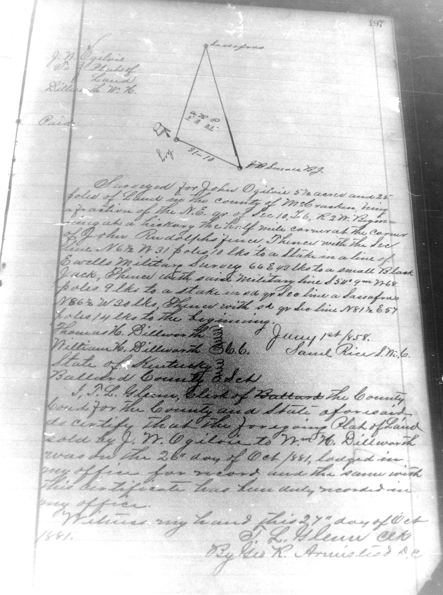
| Atherton, Thomas H. | Olive L. Atherton, his wife | Straughn, Charles H., of McCracken Co., KY | Deed | C-304 & 305 | 11 Sep 1879 | Recorded: 12 Sep 1879; Re-recorded: 9 Aug 1881 | $1300 for 150 acres, on the waters of Mayfield creek, being Lots Numbered 6, 7, 8, 9 and 1 (one) in the division of lands of John Atherton, deceased, among his children and heirs |
| Ashbrook, Daniel | Sarah Ashbrook, his wife | Megary, Zachariah | Deed | C-325 & 326 | 24 Mar 1851 | Recorded: 9 July 1851; Re-recorded: 13 Dec 1881 | $400 for 160 acres on the SE quarter of Sec 14, T 4, R 2 W, except the 50 acres held by Martha Ashbrook as dower during her natural life |
| Allison, Fannie A., et al. | Barlow, C. J., deceased Estate | Division of Intestate Estate | C-398, 399, 400 & 401 | 2 May 1876 | Recorded: 20 June 1879; Re-recorded: 10 Feb 1882 | The lands of T.J. Barlow, dec'd., having died intestate (without a Will) and having real property on the lines of Frelin (?) Tharp and Brutus P. Clay, less 20 acres sold by Barlow during his lifetime to ___ Russell, next to the Clay land above, are hereby granted jointly and severally to Barlow's wife, Susan Barlow, and the following children: Fannie J. Allison, wife of Jno. W. Allison; J.C. Barlow, Thomes J. Barlow (wife Mollie W.), James M. Barlow (wife Mollie) and C.J. Barlow (wife Mary E); Susan has relinqiushed her dower for a child's part; and real property of 61 & 1/2 acres on the Pidgeon's line, less 1 & 1/2 acre | |
| Allen, Lacy G., of Benton Co., TN, by his agent in fact James Reeder | Mary E. Allen, late Mary E. Richardson, his wife | Ashworth, James H. | Deed | C-439 & 440 | 24 Dec 1858 | Recorded: 24 Dec 1858 & Re-recorded: 27 Apr 1882 | $350 for acres on the Mississippi river, being half of the SW quarter of Sec 35, T 4, R 4 W, descended to the party of the 1st part by her father ___ Richardson, who was the son & heir of John Richardson, dec'd, |
| Allen, William H. | M. R. [or M.F.] Allen, his wife | Collins, J. H. (or J.K.) | Deed | C-450 & 451 | 28 Oct 1879 | Recorded: 7 Nov. 1879; Re-recorded: 28 Apr 1882 | $72 for acres, part of the Southern portion of Sec. 35, T 5, R 4 W, formerly owned by George Reeves |
| Ashbrook, Thomas | Lovelace, F. B. | Deed | C-472 & 473 | 17 Jan 1875 | Recorded: 7 Apr 1875; Re-recorded: 3 May 1882 | $25 for 1 quarter of an acre on the Blandville Road, and on Ashbrook's original corner on the Blandville and Lovelaceville Road | |
| Adams, John G. | Mantle, G.W. | Deed | C-571, 572, 573 & 574 | 28 Oct 1876 | Recorded: 22 Nov 1876; Re-recorded: 15 Aug 1882 | Whereas G. S. Johnson & wife sold Lot #53 and the E half of Lot #2 in Blandville, and John G. Adams, as trustee of C. V. Adams and her husband F.M. Adams, sold the land described therein to Bridges in 1860, who conveyed it to Asa Richardson, and the Adamses also conveyed another tract bought from Johnson to Richardson, which Richardson devised by Will to his wife Martha Richardson, etc. | |
| B | |||||||
| Brackin, John A., of Obion Co., TN | M.A. | Lovelace, A. | Deed | C-49 & 50 | 15 Apr 1876 | Recorded: 28 June 1876; Re-recorded: 28 Apr 1881 | $30 for 1 and 1/4 acres, adjoining the town of Lovelaceville and beginning in the SE corner of Wilson's land, then S with the road (which is an extension of Jefferson St.) to Lovelace's line, W to a N & S line of Lovelace's meadow field, thence N to Wilson's. |
| Badger, Geo .S., of Columbus, Hickman Co., KY | Sarah M. | Hamilton, Jacob | Quit Claim Deed | C-58 & 59 | 18 May 1869 | Recorded: 30 July 1873; Re-recorded: 18 May 1881 | $500 for acres, the SW Quarter of Sed 29, T 5, R 2 W |
| Brown, Thos. | Anna B. | Hunter, Wm. | Deed | C-60, 61 62, 63, 64 & 65 | 17 Jan 1870 | Recorded: 15 Feb 1875; Re-recorded: 28 May 1881 | My pages 59 & 60 missing: This appears to be the sale two military survys of 1000 acres each entered by John Gerault on the waters of Caney creek, both bounded in part by the surveys of Rich Taylor, Chas Russell, John Williams, Merriweather, Ed Carrington, and Carter. John Willis and George Barnes as trustees of Annie B. Archer; being the same land Rich L. Archer inherited from his father Archer deceased and afterward conveyed by Rich L. Archer to John Willis and Geo. Barnes as Trustees of Anna B. Archer, who conveyed to Thomas Brown |
| Bigger, J.M., Commissioner, on behalf of A. Smith and J.A. Young | Hamilton, J. | Commissioner's Deed | C-80 & 81 | 3 Mar 1852 | Recorded: 30 Apr 1852; Re-recorded: 2 June 1881 | $ 300 for 360 (?) acres in the SW quarter of Sed 13, T 5, R 2 W, sold at auction by the Court Commissioner in pursuance of a decree entered Oct Term 1849 re: Jacob Hamilton vs. A. Smith & J. A. Young | |
| Brummel, John D. | Catherine | Gardner, David, of McCracken Co., KY | Deed | C-97, 98 & 99 | 1 July 1868 | Recorded: 3 Apr 1869; Re-recorded: 6 June 1881 | $5681.25 for 115 1/4 acres adjoining the lands of Gus Vance, __ Rice, and on Kemp's 1000 acre survey and the road from Paducah to Cairo; and, 112 acres 7& 20 poles, being a portion of the NE quarter of S 33 T 7 R 2 W, on Kemp's line, Humphreys creek, and the military line supposed to be the Ewell and Travis; and 29 adjoining acres to the N & E of the above lands and known as the Quigley land. |
| Bugg, J.W., Comm. | Oldham, O.H. | Commissioner's Deed | C-125 & 126 | 14 Mar 1870 | Recorded: 18 Mar 1870; Re-recorded: __ July 1881 | In the case J.F. Harris Ptfs vs. Joel Oldham, Deft., the Sept Ballard Circuit Ct. appointed Z.W. Bugg as commissioner to convey and sell the real estate of defendant. At public auction on 26 Oct 1868, the property, consisting of 150 acres on Shawnee creek on the lines of the bluff over Reynolds line and on Ross's and Reynolds' lines, sold for $839.69. | |
| Bugg, Mary E., formerly Mary E. Sanders | Sanders, John James, Nancy Bell & Jerhome [or Jerome] B. | Deed of Gift | C-133 & 134 | 1 July 1863 | Recorded: 2 Dec 1863; Re-recorded: 30 July 1881 | $1 and the natural love and affection the party of the first part holds for the children of Mary E. and heirs of Jerhome B. Sanders, dec'd, grants all her interest in and to 320 acres on the waters of Obion, in the NE and SE quarters of Sec 27, T 4, R 2 W | |
| Bugg, Mary E., formerly Mary E. Sanders | Sanders, John James, Nancy Bell & Jerhome [or Jerome] B. | Deed of Gift | C-134 & 135 | 24 Dec 1865 | Recorded: 13 Jan 1866; Re-recorded: 30 July 1881 | $1 and the natural love and affection the party of the first part holds for the children of Mary E. and heirs of Jerhome B. Sanders, dec'd, grants all her interest in and to 60 acres to be laid off in a square and 20 acres of land formerly deeded by the party of the first part by deed of record in the Ballard Co. Clerk's office | |
| Bourland, R. | Byrd, Elizabeth | Deed | C-148 | 1 Jan 1850 | Recorded: 29 Apr 1852; Re-recorded: 16 Aug 1881 | $300 for 160 acres, being the NE quarter of Sec 14, T 6, R 2 W | |
| Brent, John Q. & wife Claracy B., Crawford Williams & wife Susan M., & James M. Williams & wife Nancy M. Williams | Brent, Harrison | Deed | C-161 & 162 | 6 Mar 1876 | Recorded: 6 Mar 1876; Re-recorded: 18 Aug 1881 | $60 an entire undivided interest in acres, known as the SE quarter of Sec 12, T 4, R 3 W, also known as the quarter on which Jonathan Ellis, Sen., lived and died, being the land inherited by the heirs of Jonathan Ellis, Jr., dec'd. | |
| Bone, Martha D. | Meshew, J.N. | Deed | C-265 | 12 Aug 1872 | Recorded: 24 Sep 1872; Re-recorded: 3 Dec 1881 | $300 for 1/2 of 50 acres deeded by Elijah Ramsey & wife to F.M. Meshew and Martha D. Bone. | |
| Bayles, H.S. | Bayles, H.W. | Deed | C-276 & 277 | 15 Feb 1877 | Recorded: 16 Mar 1877; Re-recorded: 6 Dec 1881 | $1 & the love and affection I have for my brother H.W. Bayles, the West half of Lot No. 1 in the Town of Arlington | |
| Bayles, H.S., of Arlington, Ballard Co., KY | Gish, William A., of Columbus, Hickman Co., KY | Deed | C-277 & 278 | 7 Oct 1878 | Recorded: 13 Dec 1878; Re-recorded: 5 Dec 1881 | $1,100 for half of Lot No. 1 in the plan of the town of Arlington | |
| Bugg, Z.W. Commissioner | Campbell, T.D. | Commissioner's Deed | C-294, 295 & 296 | 6 Oct 1865 | Recorded: 9 Feb 1866; Re-recorded: 8 Dec 1881 | In the case of T. D. Campbell Plaintiff vs. D.B. Briney & Wm. Sams, the Court ordered sold the tract of land in the Judgement to T. D. Campbell for $297, being 60 acres off the E side of the NW quarter of Sec 36, T 5, R 3 W | |
| Beall, Peter R., of St. Louis City & County, MO | Kate Beall, his wife | Campbell, Dillon | Deed | C-321 & 22 | 1 Feb 1875 | Recorded in St. Louis: 8 Mar 1875; Recorded in Ballard Co: 21 Oct 1875; Re-recorded: 12 Dec 1881 | $500 for 160 acres on the waters of the Mississippi River, being the SW quarter of Sec. 3, T 4, R 4 W |
| Bugg, M.E. | Lemmons, Fielding and Mary E. Bugg | Marriage Contract | C-340 & 341 | __ Mar 1871 | Tests: E. C. L. Denton, T.R. Greene; Recorded: __ Aug 1871; Re-recorded: 15 Dec 1881 | The parties wishing to marry and each having both real & personal property, that all such property shall remain the property of the party who brought it into the marriage. | |
| Birkhead, Martha H. | Donuky, Thomas H., her son | Deed of Gift | C-380 & 381 | 23 Nov 1868 | Recorded: 25 June 1868; Re-recorded: 23 Jan 1882 | $1 and all the love and affection she has for her son, 94 acres on Quigley's line and the waters of Obion creek | |
| Bayles, R.A. | Wyley, Sallie [or Wiley] | Deed | C-395 & 396 | 9 Jan 1874 | Recorded: 15 Feb 1875; Re-recorded: 10 Feb 1882 | $250 for Lot #9 in the town of Nevill | |
| Barlow, Susan | Barlow, C.J., dec'd | Allison, F.A., et al. | Division of Estate | C-401, 42 & 403 | 2 May 1876 | Recorded: 30 June 1879; Re-recorded: 11 Feb 1882 | Continuation of pages C-398-401 |
| Brown, John T. and wife Mary E., and W.C. Brown | Herring, William L. | Deed | C-410 & 411 | 30 July 1877 | Recorded: 29 Aug 1877; Re-recorded: 13 Feb 1882 | $165 for 2 acres and 19 poles for a lot in the town of Milburn, known as the one that was bought by L. N. Calvert from L. M. Horne on 15 Jan 1860, except for a piece that was sold off by E.B. Lovelace, the aforesaid house and lot was willed by L.N. Calvert to E.B. Lovelace and wife, John L. Brown and wife, and Wm. C. Cavert and wife | |
| Blanks, James | Sarah C. Blanks, his wife | Lane, John B. | Deed of Gift | C-414 & 415 | 12 Dec 1871 | Recorded: 12 Mar 1872; Re-recorded: 18 Feb 1882 | Blanks and Lane conveyed to Joseph P. Skinner, the West half of a certain tract purchased by them from James B. Husbands. Blanks here conveys to Lane for $1, the East half of said tract, the whole of which contains 142 and 1/2 acres and being that land on which Lane now lives |
| Brown, P.S. | Ophelia Brown, his wife | Henderson, Thos. | Deed | C-429, 430 & 431 | 23 Apr 1881 | Recorded: 16 Mar 1882 | Recapitulation of Deed: On or about the 23 Oct 1867, 60 and 1/2 acres on the waters of Shawnee creek, Being a part of the NW quarter of Sec 3, T 6, R 3 W, on Henderson's line |
| Bodkin, Benjamin F. | Martha J. Bodkin, his wife | Terry, Michael | Deed | C-435, 436 & 437 | 12 Oct 1865 | Recorded: 17 Oct 1865; Re-recorded: 26 Apr 1882 | Recapitulation of Deed: In consideration of the sale of the land on which Terry now lives to Bodkin, Bodkin sells the following land to Terry: 153 acres, part of S. Keen's survey of 1100 acres, on the lines of K. W. Sturman, the West line of the original survey, and J. Wilson, purchased by Bodkin of Vance; plus an additional 40 acres, being one quarter of the land bought by Bodkin of the widow of John Williams, dec'd., and on which he lived at the time of his death |
| Brummal, John D. | Catherine Brummal, his wife | Lovelace, F. B. | Deed | C-473, 474 & 475 | 20 Aug 1879 | Recorded: 5 Sep 1879; Re-recorded: 3 May 1882 | $1,450 for 145 acres on the waters of Humphreys creek, on the lines of Vance and the section line, being the same land conveyed by one Piper to James Turner, and by Turner to E.K. Owsley, and by Owsleu to Samuel Pribble (?), and by Pribble to Samuel Edwards, by decree of the US Circuit Court for the District by J.H. Ashcraft deputy of E.H. Hussay (?) US Marshall to Jacob Corbett, and by Corbett to John D. Brummel |
| Briney, Elizabeth, and David her husband; and, Emily Watson and her husband Asa. | Deweese, Wm. E. | Deed | C483, 484 & 485 | 18 Mar 1882 | Beginning of Page 485 is blank | Recapitulation of Deed: In the division of lands of John Dudley, dec'd, by surveyor Gib (?) Dalton, the Briney's received Lot No. 6 consisting of 6 acres in Sec. 18, T 5, R 2 W. Hellenny (?) Downey and James Downey her husband rec'd Lot 4 of 8 acres, Emily Watson & husband received Lots 1 & 3 for 16 acres, and 14 acres in the Sawer (?) tract. [Note: Apparently this transfers only Elizabeth and Emily's shares.] | |
| Brown, R.D., of Randolph Co., Arkansas | Brown, E.H., of Calloway Co., KY | Deed | C-485, 486 & 487 | 29 May 1878 | Attest: Nannie Driskill and L.W. Ross; Recorded in Calloway Co., KY Aug 2, 1878; Recorded in Ballard Co., 27 Mar 1879; Re-recorded: 5 May 1882 | $2,000 for the remainder interest after the expiration of homestead of Sarah Camp, widow of R.S. Camp, dec'd, being several pieces of land in Calloway Co., KY; and 225 acres in Ballard Co., the land purchased by me of N. & M.A. Daniel, known as part of the Dr. Martin tract of land, on the N by the Richards and Semple tract, W by D. McGuire tract, S by _____ | |
| Sublett, J. H. | Margaret E. Sublett, his wife | Helton, John W. | Deed | C-607 & 608 | 8 Jan 1872 | Recorded: 6 Feb 1872; Re-recorded: 31 Aug 1882 | $3,800 for acres, conveyed to Sublett by J. W. Dance in 1863 [or 1865], being on the NE corner of Piles quarter and the SE corner of Sec 28, T 7, R 2 W |
| Brown,T. A., and S. W Griffith | J. T. Brown and Sally A. Griffith, their wives | Willingham G.W. | Deed | C-515 & 516 | 4 Dec 1876 | Recorded: 23 Dec 1876; Re-recorded: 9 June 1882 | $700 for 50 acres, the lands that descended to T.A. Brown, late Griffith, and S. W. Briffith by the death of their Mother, Catherine Griffith, bounded on the W by the creek, on the N by W.A. Morgan, the E by Hall & Webb, and on the S by the old homestead |
| Bowman, James H. | Coffee, William M. | Deed | C-539 & 540 | 1 June 1861 | Recorded: 18 Dec 1861; Re-recorded: 20 June 1882 | $390 for 201 (?) acres, bought by Bowman from L. S. Lee, Sheriff of Ballard Co., as the property of H.C. Coffee | |
| Byrne, Mary E. | Mantle, George W. | Deed | C-565, 566 & 567 | 16 May 1876 | Recorded: 7 June 1876; Re-recorded: 22 July 1882 | Where Geo W. & Fanny A. Mantle sold their house (known as the Mantle House), stable lot & family grocery to R. F. Robertson for $4,000, and Robertson sold for $1,500 to Mantle the house in which Robertson lived, the same deeded by J.D. Ross to Robertson and known as Lot #27 in Blandville, here, Mary E. Byrne (in her own right & as executrix of M.H. Byrne, dec'd) sells for $4,800 240 acres on Mayfield Creek known as the land bought by Marcellus Byrne from J.M. Unsell, including Mantle selling her said Lot #27 for $1,500 cash and assigning her the remainder due from Robertson (see deed for more) | |
| Ballentine, James M. | E. J. Ballentine, his wife | Hudson, Felix G. | Deed | C-597 & 598 | 14 Oct 1876 | Recorded: 12 Nov 1876; Re-recorded: 18 Aig 1882 | $275 for 16 acres, being part of the old homestead of R.N. Wyatt, deceased, and being Lot #2 in the division among his children and heirs, and the suit of Brainer & wife vs. J. T. Wyatt & others in the Ballard Co., Court, and being deeded by said Brainer & wife to Ballentine in 1875 |
| Boyd, Leroy | Todd, Samuel | Deed | C-603, 604 & 605 | 25 July 1882 | Recorded: 31 Aug 1882 | Recapitulation of two deeds: one made 1 Mar 1860 for 62 acres, being part of Woodson's Military Survey on Obion creek, bounded by the lines of Woodson's and W.B. Thompson's surveys; and, on 25 Feb 1860, 131 acres on Woodson's line and Thompson's original line. Note: 1/4th acre of the 131 acres is reserved for a graveyard | |
| Barber, Sallie B. [or Barker] | James H. Barker, her husband | Gupton, P.H. | Deed | C-627 & 628 | 26 Aug 1876 | Recorded in Caloway Co., KY: 28 Aug 1876; Recorded in Ballard Co: 13 Octr 1876; Re-recorded: 7 Sep 1882 | $850 for __ acres, known as the SW quarter of Sec 9, T 5, R 2 W |
| C | |||||||
| Collins, J.S. | R.T. | Cherry, Ann, wife of William Cherry | Deed | C-5 & 6 | 10 Nov 1875 | 11 Apr 1881 | 42 acres on the SW corner of James McDaniel's 100 acre tract |
| Corbett, Jacob, on behalf of the Commonwealth of KY | Manrous, Philip | Commissioner's Deed | C-75 & 76 | 6 Apr 1846 | Recorded: 6 Apr 1846; Re-recorded: 2 May 1881 | $63.43 by a heir of Mary B. Watts at public auction to redeem 540 acres of 1343 1/2 acres lying on the Ohio River and taken for taxes due, being the same land conveyed by T.H. Flournoy to James O'Bannon | |
| Cates, O.G., of Frankfort, KY | Mary W. | Manrous, Philip, of Paducah, KY | Deed | C-76, 7 & 78 | 30 Aug 1846 | Recorded: 4 Dec 1846; Re-recorded: 3 May 1881 | $850 for 500 acres on or near the line that divides Ballard from Hickman Co., on the Obion creek, about 8 miles west and back from the town of Columbus on the Mississippi river, being the Northern half of a survey of 1000 acres patented to Christopher Reeves, on the line of the surveys southern half sold by Cates to the devisees of Lockridge, on the lines of H. Vowles near W. Piles farm, Bradley and R. Taylor |
| Cohin, David [or Cothin] | Flora A. | Melton, H.P. | Deed | C-87 | 25 May 1881 | 2 June 1881 | Replacement for deed made _ _ 187_, wherein $800 was paid for 2 lots (45 & 46) on Liberty Street, except for 55 feet off of the North side of Lot No. 45, being the lot occupied by F.P. Adas when he taught school in Blandville and conveyed by Adams to Ellenor Maude and by her to S.H. Jenkins and by Jenkins to Cohen |
| Crouch, R. J. | Martha Crouch | Howle, Mary K. | Deed | C-102 & 103 | 20 Oct 1868 | Recorded: 7 Dec 1868; Re-recorded: 9 June 1881 | $780 for 60 acres of land to adjoin the 15 acres said Crouch sold John Ross and on which Ross built a cabin corner of which is hereafter to be established satisfactory to Mrs. Howle |
| Coleman, Joseph T. | Nancy F. Coleman, his wife | Wells, Janie T., of Massas Co., IL | Deed | C-118 & 119 | 8 Dec 1871 | Recorded: 5 Mar 1872; Re-recorded: 2 July 1881 | $525 for 20 acres on the waters of Humphreys creek |
| Chenault, J.W. | Martha F. Chenault, his wife | Watson, J. W. | Deed | C-128, 129 & 130 | 25 Oct 1875 | Recorded: 15 Nov 1875; Re-recorded: 29 July 1881 | $200 for 100 acres on the lines of Charles Chenault's 50 acre tract in the Bigger line, Posting's (?) field line, Bigger's 400 acre line, Bill Young's line, and Brown's line |
| Chenault, J.W. & wife Martha F.; Samuel Williams & wife Alpha A., and J.A. Graves & wife Elizabeth J. | Brent, Harrison | Deed | C-158 & 159 | 19 Mar 1862 | Recorded: 22 June 1862; Re-recorded: 18 Aug 1881 | $60 for their unidvided interest in acres, known as the SE quarter of Sec. 12, T. 4, R 3 W, also known as the quarter on which Jonathan Ellis, Sen. lived an died, being the land inherited by the heirs of Jonathan Ellis Jun, Dec'd., from his father. | |
| Culver, L.D. | Culver, S. R. | Deed | C-170 | 16 Nov 1874 | Recorded: 9 Aug 1875; Re-recorded: 20 Aug 1881 | $1000 for ___acres for one half of the SW quarter of Sec. 14, T 6, R 2 W, and originally purchased of Wm. Edrington heirs | |
| Caruthers, S. | E. P. Caruthers, his wife | Scott, T. F. | Deed | C-177 & 178 | 8 May 1879 | Recorded: 8 May 1879; Re-recorded: 22 Aug 1881 | $132.50 for 13 acres on the waters of Mayfield creek, bounded on the NE corner by tract on which Caruthers now lives, west with Scott's line and Rudolph and Caruthers lines , thence south with Hopkins line, and thence with the meanders of Billington creek to the beginning |
| Corbett, Jacob | Brummell, John D., of McCracken Co., KY | Deed | C-203 & 204 | 23 Sep 1881 | Recorded 8 Nov 1881 | $2,000 for 122 acres conveyed to S. Edwards by J.C. Brooks; 231 acres conveyed to S. Edwards by Hollowa & 145 acres conveyed to S. Edwards by S. Tribble and a Lot in the Town of Woodville conveyed to S. Edwards by S.C. Vaughn; and the whole conveyed by Ashcraft, Deputy to US Marshall 8 Aug 1881. | |
| Coil, Adam M. | Dorcus Coil, his wife | Martin, Geo. | Deed | C-211 & 212 | __ ____ 1858 | Recorded: 1 Nov 1859; Re-recorded: 25 Nov 1881 | $80.00 for 54 acres, with a reserve of 1/2 acre for a grave yard, where some of C.B. Young's family are buried, on the NE corner of Sec 27, T 5, R 3 W, on the lines of M. Davis, Hall and Ramsey, Howell Crogan & Elliott |
| Corbett, Jacob Sr. | Trice, Mary L., wife of G.W.L. Trice | Deed | C-217 & 218 | 7 Oct 1881 | 25 Nov 1881 | Recapitulation for $1 consideration of deed dated 14 Oct 1875, of acres lying on the waters of Humphreys and being the Eastern part of the tract conveyed by W.P. Griffith to G.W.L. Trice and Sam Hook on July 22, 1875; the land partitioned by them, the Eastern part to Trice, being the same tract conveyed by R.T. Allbritton, Sheriff of Graves Co., KY, to jacob Corbett Sr. 28 Oct 1874 | |
| Chenault, John W. & his wife Ann M.F. Chenault; M. L. Chenault & his wife Mary Chenault; E.S. Chenault & M. Ann Chenault his wife, A. Wright & her husband S.R. Wright, Martha W. Fisher & her husband M. H. Fisher, and Nancy McDaniel, and Elizabeth Porter, heirs of C. B. Chenault, dec'd. | Holder, Sarah | Deed | C-226 & 227 | 21 Aug 1877 | Recorded: 13 Dec 1877; Re-recorded: 26 Nov 1881 | $1700 for 100 acres on Canney [Caney (?) creek, and known as the land deeded Aaron McDaniel by Daniel W. Jones, Attorney-in-fact for Jessie Landle (?) deceased, and by McDaniel to C.B. Chanault, and near the line of Thos. Carter's 12 acre Survey, | |
| Carpenter, C.A. | Sarah J. Carpenter, his wife | Nichols, Oscar F. | Deed | C-243 & 244 | 1 Aug 1863 | Recrded: 9 Nov 1863; Re-recorded: 30 Nov 1881 | $545 for the house and lot now owned by Carpenter and known as the Ford property, being lot No __ in Blandville, and also 2 lots on the SE corner of the New Carpenter addition to the town of Blandville, known as the shops lots formerly occupied by Carpenter as a blacksmith and Wagon shop and being a part of the same land purchased by Carpenter of C.P. Ray and by him of J.M. Yovock. |
| Clark, Isaac, of Christan Co., KY | Julianna Clark, his wife | Garrott, Isaac, of Christan Co., KY | Deed | C-254 & 255 | 30 Mar 1855 | Recorded: 15 June 1855; Re-recorded: 1 Dec 1881 | $9,000 for 1,000 acres on the waters of Humphreys creek, adjoining the old Tom Terrel tract on the North; and 775 acres on the waters of Clanton creek adjoining Terrell's tract on the West: on the lines of O. Turner's, Moore, a marker G.C. (for Green Clay) on the Harris survey, the flats of Humphreys creek, and W.F. Norton's |
| Coil, S.B. Commissioer, on behalf of the William Davis Heirs, namely: Clary, Charles, & Wm Davis | Frisk, Nicholas | Commissioner's Deed | C-316 & 317 | 24 May 1875 | Recorded: 21 July 1875; Re-recorded: 12 Dec 1881 | The Ballard Court of Common Pleas ordered land sold in the case of John T. Davis Plaintiff vs. William Davis Admin. Defendant; therefore the Commissioner sold at auction, a one fourth interest in 200 acres on the Westfork of Mayfield creek, laid off for dowery for Clary Davis now Smedley, in the land of John R. Davis deceased. | |
| Cothes, Herman, of the State of Texas | Linthicum, S. | Deed | C-324 | 7 Sep 1876 | Original Certificate showing Recorded date lost; Re-recorded: 12 Dec 1881 | $350 for 50 acres on the SW corner of the Livingston Suvey | |
| Cavett, T. L. | Muncell, James | Deed | C-329 & 330 | 13 Feb 1875 | Recorded: 27 Aug 1875; Re-recorded: 14 Dec 1881 | $358.84 for 32 and 1/2 acres, being part of the SW quarter of Sec. 35, T 5, R 3 W, and being Lot No. 2 in the division of the heirs of ___ | |
| Carmack, Thersa A., of Pulaski co., MO | John Carmack, her husband | McBride, P.S. | Deed | C-341 & 342 | 26 July 1881 | 22 Aug 1881 | Recapitulation for $30 consideration of deed dated 22 Nov 1879, convey 8 acres, being Lot No. 6 of 7 lots in the division of Alexander Ransey, dec'd, lying on the waters of Mayfield creek & adjoining James Munsell on the West, Simon McBride on the North, John Partir (?) on the East and Jonathan Ellis on the South. |
| Commercial Bank of KY, of McCracken Co., signed by Q.Q. Quigley, President | Shelby, A.M. | Deed | C-365, 366 & 367 | 6 Sep 1881 | 3 Jan 1882 | Recapitulation of deed made on 4 Oct 1873, $___ for 346 and 1/2 acres of Lot #1, being at a corner on the Ohio River at Elm, and middle of Slough, with a lower corner at the mouth of Gar creek on the Ohio River and adjoining Oscar Turner's land which is the upper half of Lot #1 in the Subdivision of Harry James' tract in the Gen. George Rogers Clark Treasury Survey | |
| Crice, John | and wife | Crice, William F. | Deed of Gift | C-375 & 376 | 26 Dec 1850 | Recorded: 21 June 1864; Re-recorded: 6 Jan 1882 | For love and respect, 236 acres on the waters of Hasel creek, being a part of Col. Harris's Survey which was deeded to me by Richardson's heirs |
| Carroll, James K., Heirs: James K. Carroll & his wife A.M. Carroll, Pleasant N. Carroll, Thomas Jones & P.E. Jones his wife, T.L. Carroll & his wife Nancy P. Carroll | Carroll, R.M. | Deed | C-390, 391 & 392 | 19 Aug 1879 | Recorded: 31 May 1880; Re-recorded: 9 Feb 1882 | $9 to each of the heirs, excluding Thomas Janus, for 360 acres in Miller County, MS, including about 40 acres in Sec 7, T 3, R 2, 40 acres in Sec 8, T 37, R 12, and the balance in Sec 3, 12, 13 & 14 in T 37 R 13; viz: James K. , T.L, and P.N. Carroll, and P.E. Jones each convey 1/8th undivided interest in the South half of Sec. 24, T5, R 3 W to R.M. Carroll, known as part of the R.R. Taylor farm and conveyed to Joseph Carroll by the Ballard Circuit Court Commissioner 19 Mar 1870, and half of the same land bought by R.R. Taylor from Elliott | |
| Cavett, Malinda A. (formerly Tankersly) | Thomas L Cavett, her husband | Reeves, Y. C. | Deed | C-405 & 406 | 5 Oct 1878 | Recorded: 16 Oct 1878; Re-recorded: 11 Feb 1882 | $40 cash for acres being one third of one fifth of the McCuistain tract of land in Sec. 34, T 7, R 3 W on the waters of Humphreys creek |
| Chenault, C.B. | McDaniel, A. | Deed | C-413 & 414 | 21 Sep 1869 | Recorded: 8 Dec 1869; Re-recorded: 13 Feb 1882 | $3,000 and the willingness of Chenault to support McDaniels for his natural life for $500 of that price, so long as Chenault lives with McDaniel, for 160 acres, being the SW quarter of Section 7, Township 4, Range 2 West | |
| Corbett, Jacob | Marshall, Millie | Deed | C-426 & 427 | 4 Sep 1878 | Recorded: 19 Sep 1878; Re-recorded: 16 Mar 1882 | $100 for a 1 acre lot in the town of Blandville, on the street or Road leading from there to Paducah, running 210 feet by 210 feet |
| Collier, Harriett, of McCracken Co., KY | B.F. Collier, her husband | Stovall, Mary S., by her Agent, James M. Lovelace | Deed | C-461 & 462 | 5 June 1873 | Recorded: 14 Aug 1875; Re-recorded: 1 May 1882 | $39.61 for an undivided half interest in two town lots (#107 & 108) in the town of Lovelaceville, deeded to Harriett Hammons, now Collier, and her brother John Hammonds during their minority by the late Andrew Lovelace, the original proprietor of the town of Lovelaceville |
| Corbett, Thomas P. | Rebecca Corbett, his wife | Gupton, Pleasant H. | Deed | C-625, 626 & 627 | 10 Nov 1873 | Recorded: 10 Nov 1873; Re-recorded: 7 Sep 1882 | $1,350 for 180 acres, it being Mrs. Ellen Atherton & Daniel W. Atherton's entire interest in the that Caneday Atherton willed to Ellen & Dan'l Atherton, and the same place on which Canada Atherton died; it being the NE quarter of Sec. 17, T 5, R 2 W; and a part off of another quarter; the same Daniel and Ellen Atherton tract contains 106 acres, the balance of the tract having been sold to Josiah Lowe |
| Coffee, Hugh G. | Elizabeth Coffee, his wife | Coffee, William M. | Deed | C-541 | 18 Feb 1861 | A copy Attest: J. Corbett, clk; Re-recorded: 20 June 1882 | 900 for 60 acres on the waters of Mayfield creek, being the SW corner of the SE quarter of Sec. 31, Twp. 6, R 2 West, it being the land upon which H.G. Coffee lived, and sold by M.S. Preston to Nathan Coffee |
| Coffee, Hugh G. | Coffee, William M. | Deed | C-544 & 545 | 17 Nov 1874 | Recorded: 19 Nov 1874; Re-recorded: 21 June 1882 | In the case of G.A. Stegall and W.M. Coffee Plffs. vs. H.G. Coffee, Deft., concerning a quarter section of land plus a partial section to the South, known as the old H.G. Coffee farm, to which W.M. Coffee claims all rights and H.G. Coffee claims an interest, & also a claim of Forcible Entry in the name of Elbert Flood against Stegall now pending; a compromise was reached based on a surveyor's line establishing the section lines [Thomas Flood's name also mentioned) | |
| Clandy, Ann F., of Christian Co., KY | J. D. Clandy, her husband | Byrnes, M. H. | Release of Dower | C-563, 564 & 565 | 19 May 1875 | Recorded: 29 May 1875; Re-recorded: 20 July 1882 | Clandy having sold 400 acres on the waters of Mayfield creek to J.M. Unsell in November 1860 for $6,747.41, upon which Unsell then lived, less 45 acres encumbered with Mary White's dower rights & 20 upon which Clandy's child is buried, was not conveyed & Unsell sold a portion of the 400 acres, being the NE quarter of Sec 14, T 5, R 3 W (160 acres) and 80 acres on the West of the Sec. deeded by Jonathan Reeves to D. Ward and by him to Clandy, here Ann F. Clandy gives her dower rights for $1 & love for her husband to make his deed good |
| Cothes, Mrs. Hattie A. | H. V. Cothes, her husband | Mantle, G.W. | Deed | C-576 & 577 | 21 Mar 1878 | Recorded: 10 Apr 1878; Re-recorded: 15 Aug 1882 | $1,500 for 191acres on the waters of Mayfield creek and better known as the Herman Cothes home farm and the same upon which the said H.C. Cothes built a residence, now occupied by the widow Campbell, being the same tract of land conveyed to Cothes by G.A. Terry & wife on June 7, 1872, not including the 33 acres previously sold by Cothes to Terry; and whereas Cothes leased __ acres of said land to A. Bodkin for __ years for use as a fair ground in return for half the profits, therefore Mantle will be the recipient of the half profits due to this sale |
| Carter, W. H. | H. A. Carter, his wife | Robertson, Nancy P. | Deed | C-588 & 589 | 14 Feb 1877 | Recorded: 10 Mar 1877; Re-recorded: 17 Aug 1882 | $300 for Lot # 15 in Arlington, KY |
| Coathes, H. V. | Harriett "Hattie" A. Coathes, his wife | Smith, H. S. | Deed | C-613, 614 & 615 | 20 May 1875 | Recorded: 25 June 1875; Re-recorded: 1 Sep 1882 | $750 for 125 acres near the town of Blandville, being a part of the division made of the lands of the late Herman Coathes by the commissioners, on the lines of A. Bodkin, Logan's survey, Andrew Bodkin, Mayfield creek, J. W. Puckett's SE corner (described in the deed from J. A. Terry to Puckett), and the Blandville and Columbus Road |
| D | |||||||
| Daughtry, Rebecca | Mize, Joseph C. | Deed | C-116 | 12 July 1872 | Recorded: 21 May 1874; Re-recorded: 2 July 1881 | $300 for 60 acres on the south Bank of the lake, the bank of the Ohio River | |
| Duncan, Ben R. & wife Amanda M. "Mandy"; John Duncan & wife Catherine, Hannah Duncan, George M. Holeman & wife Sallie, Robert C. Whitessides & wife Vitula | Holt, A.B. | Deed | C-136 & 137 | 29 Apr 1871 | Recorded: 9 June 1871; Re-recorded: 9 Aug 1881 | $817 for 54 & 1/2 acres, being the sixth part of the tract of land belonging to Samuel Duncan, deceased, lying in the Northwest corner of said tract; Hannah Duncan, widow of Samuel, relinquishes her dower right | |
| Dunn, Nancy L. | Cunningham, Nette [or Netty], wife of J. Cunningham | Deed | C-184 & 185 | 30 Aug 1875 | Recorded: 3 May 1876; Re-recorded: 29 Aug 1881 | $700 for 31 & 1/4 acres, on the NE corner of Nelson's survey and Woodson's Survey | |
| Dicus, Wiley | Sabrey Discus, his wife | Dunn, Jas. | Deed | C-186 & 187 | 6 Aug 1879 | Recorded: 8 Oct 1879; Re-recorded: 28 Aug 1881 | $300 for 17 acres on the waters of the Mississippi River, on Crump's line, being the same land deeded by M.E. McDermott to Wiley Dicus |
| Duncan, John, & his wife Sarah C. Duncan; Ben R. Duncan & his wife Amanda M. Duncan, George M. Holman & Sallie Holman his wife; R.C. Whiteside & Vitula Whiteside his wife | Holt, W.H.M. | Deed | C-256 & 257 | 16 May 1870 | Recorded: 24 May 1873; Re-recorded: 2 Dec 1881 | $700 for 54 & 1/2 acres, being the South part of the Samuel Duncan, deceased, tract | |
| Davis, E.R. | Frick, Nicholas | Deed | C-314 & 315 | 13 Mar 1875 | Recorded: 7 Apr 1877; Re-recorded: 12 Dec 1881 | $220 for an undivided interest in 33 and 1/3 acres [Note: no description of land] | |
| Davis, M.M. | A.M. Davis, his wife | Bishop, S.T. | Deed | C-360 & 361 | 15 Sep 1879 | Recorded: 31 Dec 1881 | Recapitulation of deed made 15 Sep 1879, being 1/2 acre, Lot #4 NE corner of James F. Trewalla Lot No 3, W.G. Scott and the road to the Paducah and Cairo Road |
| Dupree, Anne M. | William H. Dupree, her husband | Gish, Sarah A., of Hickman Co., KY | Deed | C-382, 383 & 384 | 5 May 1866 | Recorded: 2 July 1866; Re-recorded: 2 Feb 1882 | $1400 for 70 acres on the waters of Ramsey creek, on the lines of W.M. Thompson's 1,000 acre survey, J. Burkehead, the meanders of Ramsey creek, and Woodson's military line, being part of a tract of land conveyed to Dupree by Samuel Todd and wife |
| Donaky, Thomas H. | Elizabeth Donaky, his wife | Gish, Sarah | Deed | C-384 & 385 | 14 Mar 1876 | Recorded: 2 Aug 1878; Re-recorded: 2 Feb 1882 | $40 for 1 and 3/4 acres on the waters of Ramsey creek, on the lines of Dupree, Gish and the creek, being off of the SW corner of land conveyed to me by Q.Q. Quigley |
| Davidson [or Davison or Dawson]. Thomas H., of Graves Co., KY | M.E. Davidson [or Davison or Dawson], his wife | Clayton, Robt | Deed | C-424, 425 & 426 | 23 Sep 1879 | Witness: C.M. Knapp; Recorded: 16 Mar 1882 | Recapitulation of deed made 23 Sep 1879, being a portion of Sec 36, Township 4, Range 2 West, containing 120 acres, for which $754 was paid |
| Dent, William, of McCracken Co., KY | Milly Dent | Dilworth, Felix G. | Deed | C-491, 492 & 493 | 1 Mar 1858 | Attest: B. Small & I. Leslie Brown; Recorded in McCracken Co., KY: 1 Mar 1858; Recorded in Ballard Co: 3 Mar 1858; Re-recorded: 9 May 1882 | $1,120 for 160 acres, known as the NW quarter of Sec 21, T 7, Range 2 West, being the same land conveyed to Dent by James Hawthorn in August 1843 |
| Dale, Falden (?) A. & Elijah T. McInteer | D.C. McInteer, Elijah's wife | Keen, Edmond B. | Deed | C-506, 507 & 508 | 12 Apr 1856 | Spencer Co: 21 Apr 1856; Ballard Co: 11 June 1856; Re-recorded: 12 May 1882 | $753 for 182 acres on the waters of little Caney creek and some of the branches of Hazel creek, on the lines of Russell & Eaden's 200 acre tract, Tharp, and Clay, |
| Dupoyster, Joseph C. | Rebecca M. Dupoyster, his wife | McCourt, Henry S. & his wife Elizabeth B. | Deed | C-554, 555 & 556 | 4 May 1875 | Recorded: 14 Sep 1875; Re-recorded: 27 June 1882 | Dupoyster & McCourt were joint owners in fee simple of a tract of land, and Dupoyster deeded his undivided half interest to McCourt in 1872, Dupoyster hereby deeds the remainder to McCourt in return for a deed and $1 for 116 acres in the Logan survey and 143.63 acres in the Todd survey on the east bank fo the Mississippi river at the line between the Todd and Logan surveys, the mouth of Dupoyster's lane, Mayfield creek and to the creek's mouth in to Island Chute, and embrasing the town of Fort Jefferson, etc. including another 172.27 acres |
| Dawson, C. C. | M. B. Dawson, his wife | France, Frank | Deed | C-624 & 625 | 30 Oct 1877 | Recorded: 2 Dec 1877; Re-recorded: 9 Sep 1882 | $1,100 for 50 acres, being the N side of the NE quarter of Sec 3, T 4, R 2 W, and also 25 acres on the SW corner of the SW quarter of Sec. 34, T 5, R 2 W, and Atherton's line |
| Davis, S. M., and C. R. Pile | S. E. Davis and Mattie Pile, their wives | Robertson, D.B.S.P. | Deed | C-589 & 590 | 12 Oct 1877 | Recorded: 6 Nov 1877; Re-recorded: 28 (?) Aug 1882 | $2,500 for 59 acres, together with the Mill and water power on such land, known as the Davis & Piles Mill tract of 112 acres, less 53 acres deeded to S.M. Davis, on the line of Davis's 53 acres, crossing Obion creek, then up the Obion and Ramsey creeks |
| Danse, Elizabeth A. | Hudson, Felix G. | Deed | C-602 & 603 | 30 June 1877 | Recorded: 10 Sep 1877; Re-recorded: 19 Aug 1882 | $300 for 24 acres on the waters of Humphreys creek | |
| Duncan, Samuel C. | Smith, H. S. | Deed | C-615 & 617 | 8 Feb 1881 | Recorded: 7 Mar 1881; Re-recorded: 1 Sep 1882 | $88.86 for 20 & 1/3 acres in the division of the land of H.M. [or R.M. or K.M.} Duncan in 1878, deceased, by the County Commissioners, on the lines of the Widow's dower, and other portions | |
| Durbin, Elisha J., of Union Co., KY | Megary, Beverly | Deed | C-630 & 631 | 18 July 1857 | Recorded: 1 Feb 1858; Re-recorded: 20 Sep 1882 | $100 for 20 acres on West Mayfield creek, being that portion of the SE quarter of Sec. 11, T 4, Range 2 West, lying S of West Fork of Mayfield creek, being a portion of the land I sold to Ed O'Connor and he has desired me to make to the said Megary | |
| Dalton, Mary F. , of McCracken Co., KY | Isham Dalton, her husband | Ingram, Martha | Deed | C-631 & 632 | 2 Dec 1874 | Recorded in McCracken: 3 Sep 1874; Recorded in Ballard Co: 15 Apr 1875; Re-recorded: 20 Sep 1882 | $750 for 50 acres and 11 poles |
| E | |||||||
| Ellis, Sarah E. | Williams, Nancy M. | Deed | C-41 & 42 | 11 Oct 1879 | Recorded 24 Nov 1879; Re-recorded: 23 Apr 1881 | $5 for 27 acres on the waters of Little Mayfield Creek, being lot 4 in the division of the lands of Sarah Ellis | |
| Ellis, D.T., of Henry Co., KY, by his attorney in fact, John B. Ellis | Brent, Harrison | Deed | C-159 & 160 | 1st ___ 1869 | Recorded: 12 July 1869; Re-recorded: 18 Aug 1881 | $400 for acres, the undivided interest in acres known as the SE quarter of Sec. 12, T 4, R 2 W, further known as the quarter on which Jonathan Ellis lived and died, and being the land inherited by Ellis | |
| Edrington, Elija R., L.H. D. S., B.L., and R. L. & Laura A. Haynes | Culver, L.R. & L.D. | Deed | C-168 & 169 | 14 Mar 1873 | Recorded: 10 Apr 1873; Re-recorded: 20 Aug 1881 | $1066.66 for acres, being the SW quarter of Sec. 14, T. 6, R 2 W (and original purchaed of Morrow by Wm. Edrington) | |
| Ellis, Sarah E. | Williams Susan M. | Deed | C-269 & 270 | 11 Oct 1879 | Recorded: 25 Nov 1887; Re-recorded: 3 Dec 1881 | $5 for 24 acres on the waters of Little Mayfield creek, being Lot No. 3 in the division of the Lands of Sarah E. Ellis | |
| Earle, John E., his wife Elvira E. Earle, and M.L. Earle | Burkhead, Eleanor Parlee, and her bodily heirs | Deed | C-281 & 282 | 16 Feb 1875 | Recorded: 6 May 1875; Re-recorded: 6 dec 1881 | $1,000 for 64 acres on Sec. 23, T 4, R 3 W, on Edrington's line | |
| Elliott, Z. | Eliza Elliott, his wife | Campbell, T.D. | Deed | C-293 & 294 | 3 Aug 1855 | Recorded: 24 Oct1855; Re-recorded: 7 Dec 1881 | $105.50 for 5 & 1/2 acres on the waters of Mayfield Creek |
| Edwards, Thos. | Emily F. Edwards, his wife | Deed | C-456 & 457 | 22 July 1878 | Recorded: 27 Aug 1878; Re-recorded: 29 Apr 1882 | $400 for 124 & 1/2 acres on the waters of Mayfield creek, conveyed from W.J. Reeves to J.A. Edwards, and conveyed by J.A. Edwards and his wife Alzard (?) Edwards to Thos. Edwards in 11 Nov 1872, | |
| Elliott, J., by Z.W. Bugg, Commissioner | Reeves, W.H. | Commissioner's Deed | C-477 & 478 | 7 Apr 1869 | Recorded: 4 July 1864; Re-recorded: 3 May 1882 | March Term 1863, decree in F.M. Miller vs. G.W. Howle, Z.W. Bugg auctioned 300 acres for $717.16 paid by W.H. Reeves, | |
| Elliott, Z., by Z.W. Bugg Commissioner | Trabue, James, James W.A. Davis, Thomas C. Arniss (?), Richard Trabue and Matt Neil (?) | Commissioner's Deed | C-481, 482 & 483 | 3 May 1872 | Executed: 15 April 1875; Re-recorded: 3 May 1882 | In the case of James Trabue, et al., Plaintiffs vs. Z. Elliott Defendant, and John Bird's Executors vs. Z. Elliott, et al., Plaintiffs, Ballard Circuit Count October term 1871, ordered the following property sold at auction: $300 for 66 & 2/3rds acres, being the E. part of 366 & 2/3rds acres allotted Elliott in the division between the Elliott and ____ and wife. | |
| Ellis, Sarah E. | Brent (?), Clarissa B. | Deed | C-582& 583 | 11 Oct 1879 | Recorded: 2 Dec 1879; Re-recorded: 15 Aug 1882 | $5 for 24 acres on the waters of Little Mayfield creek, being Lot #1 in the division of land among the heirs of Sarah E. Ellis | |
| Eavs, Elizabeth A. | C.C. Eavs, her husband | Lee, Cary Elizabeth, wife of Jesse W. Lee | Deed | C-635 & 636 | 25 Feb 1874 | Recorded: 22 Apr 1874; Re-recorded: 21 Sep 1882 | $480 for 80 acres on the waters of West Fork of Mayfield creek, being on the E half of the NE quarter of Sec 5, T 4, R 2 W |
| F | |||||||
| Fergerson, J.D. | Vaughn, Grandison | Deed | C-69 & 70 | 3 Mar 1872 | Recorded: 25 Apr 1872; Re-recorded: 29 May 1881 | $800 for 88 3/4 (?) acres on the lines of Bondeurant and Merriweather, being the and deeded to Fergerson by J.C. Bondeurant and wife | |
| Flournoy, Thomas H., McCracken Co., KY | Mary A. | O'Bannion, Jas., of McCracken Co., KY | Deed | C-73 | 3 Nov 1842 | Recorded: 25 Nov 1842; Re-recorded: 2 May 1881 | $735 for 540 acres, it being Mary B. Watt's Lot No. 2 in the division of John Harris Shiney made by Chiles Terrell, bounded by the SW corner of Anderson Edwards's Survey of 340 acres No. 2 on Myres line thense along Edwards line to his NW corner on Rebecca Harris' line |
| Fortson, Richard D. | Elizabeth F. Fortson, his wife | Runs, Laura B. (late Fortson), Willie F. Penn (late Fortson), C. Ray Fortson & Nannie R. Fortson | Deed of Gift | C-403, 404 & 405 | 11 Aug 1871 | Recorded: 12 Aug 1871; Re-recorded: 11 Feb 1882 | Natural love and affection they have for the named children: To Laura - 53 acres to be laid off on the S end of the tract of land on Humphreys creek and being part of the land deeded Fortson by John Fergerson of Christian Co., KY, it being the tract on which Fortson now resides and upon which George Reeves has built his house, also a 5 yr old roan mare and yearling sorrell colt, etc. |
| Fergerson, John C. | Martha Fergerson | Fortson, R. D. | Deed | C-579 & 580 | 1 Mar 1856 | Recorded: 14 Nov 1856; Re-recorded: 15 Aug 1882 | $650 for 130 acres on the waters of Humphreys creek, being a fraction of the NW quarter of Sec. 25, T 7, R 3 W |
| G | |||||||
| Griffin, W.P., of McCracken Co. | Sallie M. | Murphy, P.T & Z.T. | Deed | C-3 & 4 | 24 Aug 1874 | Recorded 11 Apr 1881 | 100 acres & 66 poles, part of the SE Quarter Sec 23 & SW Quarter Sec 24, T 3, R 1 W, in A. Lovelace's line and Ross's line |
| Gibson, William, of the State of Tennessee, by his attorney T. H. Corbett & Chas. S. Marshall | Deweese, Elbert | Deed | C-9 & 10 | 28 Apr 1865 | Recorded 11 Apr 1881 | $175 and settlement of a land dispute between the parties, conveys land on the waters of Mayfield creek, known as the SW Quarter of Sec 6, T 5, R 2 W containing 160 acres; and, 60 acres more | |
| Garner, Unis, Fred Crise, P.P. Martin & Nancy Jane Martin his wife, Hulda (?) Crise, F.L. Crise, Sarah L. Parrott, F.W. Crise and Mary S. Crice his wife, and Andres McCuistan & Malinda McCuistan his wife | Waters, Mrs. Polly, wife of Harrison Waters, dec'd | Deed | C-248 & 249 | 31 Mar 1870 | Recorded: 9 Oct 1871; Re-recorded: 1 Dec 1881 | $1 for 150 acres on the Ohio River, the same owned by John Crice at the time of his death, said land joining the land of E.A. Terrell, and Sarah L. Parrott (?) relinquishes all claims | |
| Gajani, Mary A. | Campbell, Elizabeth A. | Deed | C-284 & 285 | __ Apr 1881 | 6 Dec 1881 | Recapituation: In 1869 or 1870, B. W. Campbell, husband of Elizabeth, purchased for $900, 160 acres from M.A. Gajani, being the SW quarter of Sec 34, T 5, R 4 W | |
| Gajani, Mary A. | Campbell, Baker W. | Deed | C-285 & 286 | __ ____ 1881 | Recorded: 6 Dec 1881 | $355 for 72 acres, being a fractional part of the SE quarter of Sec 33, T 5, R 4 W | |
| Glenn, T.L. | L.J. Glenn, his wife | Richardson, J.A. | Deed | C-352 & 353 | 30 Nov 1877 | Recorded: 6 Dec 1877; Re-recorded: 30 Dec 1881 | $350 for 8 & 7/10ths acres, a lot in the town of Milburn, adjoining the lot of T.P. Hays and the land of J.N. Sanford, and bounded on the North by a lane between the land & R.T. Milburn's farm and on the East by the Blandville and Milburn road, and the land bought by Glenn from J.N. Sanford, etc. |
| Gray, John Thompson, of Franklin Co., KY | Catherine A. or Anita C. Gray , his wife | Thomas, Jesse | Deed | C-378 & 379 | 1 Oct 1868 | Recorded: 20 Jan 1869; Re-recorded: 17 Jan 1882 | $1,000 for 100 acres on Clanton creek, on the lines of William F. Thomas's 125 acre survey |
| Gish, Sarah A. | Donaky, Thomas H. | Deed | C-387 & 388 | 14 Mar 1876 | Recorded: 21 Mar 1876; Re-recorded: 8 Feb 1882 | 1 and 1/6th acres, being the NE corner of land on the waters of Ramsey creek, conveyed by Annie Dupree to Sarah A. Gish, in consideration of other lands conveyed by Donaky to Gish this day and purchased by Donaky from Q.Q. Quigley, on the ines of Donaky, Gish and the creek | |
| George, Reubin | Indiana George, his wife | Toby, J.B. | Deed | C-418 & 419 | 18 Nov 1875 | Recorded: 7 Feb 1876; Re-recorded: 14 Feb 1882 | $112 for 1 and 1/2 acres on the NW corner of J.B. Toby's lot on the North side of the Mayfield and Columbus Road, in J.F. Thompson's line and on the line of A. Reed |
| George, Reubin | Indiana George, his wife | Toby, J.B. | Deed | C-420 & 421 | 10 June 1871 | Recorded: 19 Aug 1871; Re-recorded: 14 Feb 1882 | $100 for 1 and 1/3 acres in the South West Quarter of Sec 21, Twp. 4, R 2 W, being on the SE corner of John Thompson, the North side of the Mayfield Road. |
| Gajani, Mary A. & Mary C. Bryant, of Hickman Co., KY | Ashworth, James H. | Deed | C-446 & 447 | 16 Jan 1869 | Recorded: 15 July 1869; Re-recorded: 27 April 1882 | $600 for 84 acres, adjoining E. Hogencamp and Dan'l. Bodkin, being the NW quarter of Sec 35, T 5, R 2 W, and willed to the parties by Baker Woodruff, deceased | |
| Griffin, Martha J. | Samuel Griffin, her husband | Smith, J. J. | Deed | C-504 & 505 | 18 Sep 1876 | Recorded: 10 Aug 1877; Re-recorded: 12 May 1882 | $250 for 1 town lot in the town of Hinkleville, containing 1 acre, bounded on the South by Mrs. Henderson, on the East by T.B. Straughn, the North by J.H. Dalton & the West by Ogden Landing (?) Road |
| Griffin, J. W. | Willingham, G.W. | Deed | C-517 & 518 | 2 Feb 1878 | Recorded: 11 Apr 1878; Re-recorded: 9 June 1882 | $150 for 50 acres on the waters of Lick creek, decended to said Griffith upon the death of his mother, Catherine Griffith, bounded on the N by W.F. Moyers, on the W by the creek, on the E by Hall & Webb, and on the S by the old homestead | |
| Gordon, James C., Jeanetta M. Gordon, Sillias [Silas (?)] S. Gordon, Mary C. Seabrook, Robert M. Gordon, Jesse C. Gordon, Agnes M. Fitzpatrick, and Andrew Fitzpatrick, by their Atty. In Fact, F.M. Ray | Taylor, W. Frank, and his wife Mary Ann Taylor | Deed | C-586 & 587 | 8 Jan 1876 | Recorded: 15 Mar 1877; Re-recorded: 17 Aug 1882 | $750 for 152 and 1/4 acres on the waters of Mayfield creek, being part of the James Currie military survey, | |
| Goode, Richard, of Chesterfield Co., VA | Mary A.P. Goode, his wife | Megary, Beverly | Deed | C-633, 634 & 635 | 27 May 1850 | Recorded: 24 Dec 1850; Re-recorded: 21 Sep 1882 | $550 for 250 acres, being the NE quarter and one half of the NW quarter Sec 14, T 4, R 2 W |
| Green, P. T. | Megary, Beverly | Deed | C-637 & 638 | 22 Apr 1874 | Recorded: 21 July 1874; Re-recorded: 22 Sep 1882 | $1,300 for acres, being the E half of the SW quarter of Sec 13, T 4, R 2 W, and being part of the tract of land conveyed by Daniel _. Harkless to Robert _. Green, 28 Mar 1846, | |
| H | |||||||
| Heath, William D. | Eliza | Adams, W. F. | Deed | C-14 & 15 | 15 Oct 1871 | Recorded 30 Oct 1872; Re-recorded 11 Apr 1881 | $10,000, paid $800 25 Dec 1871, $800 on 25 Dec 1873, $400 on 25 Dec 1874, and 2 notes on Morgan Sheopherd and 2 add'l notes, ?9 acres and 47 poles, on the waters of Brent creek and part of SE quarter Sec 1, T 5, R 2 W lying in the W corner of the NE Q of S 12 same T & R |
| Hawes, W.F. | W. S. Bishop, in trust for Hawes, M.E. | Deed | C-16 & C-17 | 18 Mar 1881 | Recorded: 21 Apr 1881 | Confirming transfer of personal property which took place on ___ 1876, consisting of all of th property devised of M.E. Hawes as widow of Chas. Wickliffe deceased and the real and personal property devised to M.E. Hawes as the widow of S. J. Jenkins, and that she may dispose of as she pleases | |
| Hall, Sarah J., by her Attorney J. J. Hall, and in his own right | Hall, Thompson S. | Deed | C-101 & 102 | 12 Oct 1880 | 12 Oct 1880; 7 June 1881 | (Recapitulation of a deed dated 15 Sept 1875, for 57 3/4 acres in Sec. 29, T 5, R 3 W, lying on the West side of the NE quarter, bounded on the N & E by Sloan, S by Peter Hill [or Hilt], and W by Balam Petey. | |
| Hicks, John K. | Hicks, Johnetta E. | Deed of Gift | C-111 & 112 | 14 Aug 1875 | Witnesses F.D. Yeiser & D.L. Williams; Recorded in McCracken Co., 26 June 1876; Re-recorded Ballard Co.: 20 June 1881 | $1 and natural love and affection for my only daughter and with myself, my only family, for __ acres on Settles line, also a 20 foot lane in front of my house along the fourth line therein of said Survey, also a strip for a lane 8 feet wide running at right angles nearly E from the first corner, the last two for lanes as a part of his homestead from Sal Vaughn, the whole having a value of $1000 | |
| Holt, James M. | Mary J. Holt, his wife | Holt, Abram B. | Deed | C-139 & 140 | 4 Oct 1875 | Recorded: 29 Nov 1876; Re-reccorded: 10 Aug 1881 | $800 for 67 & 1/2 acres on the waters of Clanton creek, bounded by John Holt's line |
| Holt, A. J. | Beeler, John F. | Deed | C-151 | 13 Feb 1864 | Recorded: 17 Jan 1870; Re-recorded: 16 Aug 1881 | $30 for 3 acres, it being part of Lot No. 5 on the lines of Holt's North boundary line, near the corner of the tract of Kelley's heirs | |
| Harris, Z. T. | L. A. Harris, his wife | Parten, R.H. | Deed | C-165 & 166 | 29 Nov 1876 | Recorded: __ ___ 1877; Re-recorded: 19 Aug 1881 | $900 for 80 acres on the waters of Harrison creek, known as the North half of the NE quarter of Sec. 2, T __, R 2 W |
| Holt, Rhoda | Cash, L.A. | Deed | C-200 & 201 | 13 Oct 1863 | Attest: William Puckett & A.W. Rowland; Recorded: 27 Oct 1863; Re-recorded: 1 Nov 1881 | $1900 for 80 acres, being the W half of the NE quarter of Sec 36, T 4, R 2 W; Also 33 & 3/4 acres off of the SE quarter of Sec. 25, T 4, R 2 W; also 4 acres off the SE corner of the SW quarter of Sec 25, T 4, R 2 W | |
| Hall, T.G., Mary C. Hall and her husband H.L. Hall, Almedia Hall & her husband J. Hall, M.E. Klapp, E. E. Klapp & Eliza Klapp by T.L Glenn, Commissioner | Klapp, E. E. | Commissioner's Deed | C-205 & 206 | 25 Aug 1875 | Recorded: 26 Nov 1875; Re-recorded: 19 Nov 1881 | In the action of T.G. Klapp, et al., Plaintiffs vs. Martha E. Klapp, et al., Defendants, June Term 1873 court ordered commissioners to divide of lands named. Herein ordered 25 & 1/4 acres, Lot No. 5, to E. E. Klapp on the NE corner to Lot 4 and SW corner to Lot 6 | |
| Hawes, W.F., on behalf of the heirs of Edward H. Carrington, dec'd | Patterson, James S. Widow and Heirs | Commissioner's Deed | C-222 & 223 | 4 Apr 1878 | Recorded; 28 June 1878; Re-recorded: 26 Nov 1881 | To conveya tract of 186 acres, purchased by James S. Patterson during his lifetime from the Carrington heirs, being a part of the John Williams Military Survey and on the lines of the original town plat of Columbus, and Porter's 50 acres: to Geraldine Patterson, widow of James S. Patterson for her lifetime, with a reversion to Millie, __ , and Mickey Patterson, children of James Patterson dec'd | |
| Holt, Joel F. and Abram B. Holt | Wiley H. M. Holt | Deed | C-258 & 259 | 2 Aug 1879 | Recorded: 5 Aug 1879; Re-recorded: 2 dec 1881 | Joel F, Abram B & Wiley H.M. Holt, all of Ballard Co., are all and only heirs of John Holt, deceased & by agreement the two convey to the third, 115 acres, being the South third of a tract on Clanton creek, it being the same purchased of W.A. Reeves by John Holt, known as the Upshaw land adjoining the Samuel Duncan land on Duncan's lines | |
| Holt, John | Wiley H. M. Holt | Deed | C-259 & 260 | 8 Feb 1878 | Recorded: 5 Mar 1878; Re-recorded: 2 Dec 1881 | $1,500 for 100 acres being part of the 400 acre tract conveyed Wiley Rudolph by Wm Holman | |
| Hinchey, S.K. | Jane A. Hinchey, his wife | Atherton, Jas. E. | Deed | C-300 & 301 | 9 Sep 1871 | Recorded: 3 Jan 1872; Re-recorded: 9 Dec 1881 | $600 for 154 acres on the waters of Wilsons creek, being the SE quarter of Sec 5, T 5, R 2 W on the lines of Dick Robinson and sd. Atherton, and Tabb |
| Hobbs, Chas. | Hobbs, Catherine C. | Deed | C-397 & 398 | 20 Sep 1879 | Recorded: 4 Oct 1879; Re-recorded: 10 Feb 1882 | $866 for the E half of the NW quarter of Sec. 9, T 4, R 2 W, to be divided as agreed with G.R. Ryan and others, 2 acres on which my house stands, all of which I purchased from G.R. Ryan, and also my part of the tract purchased by me and M.A. Hobbs of H. Ryan, lying E of the aforesaid half quarter | |
| Horne, L.M. | Louisa E. Horne, his wife | Calvert, L.N. | Deed | C-408 & 409 | 15 Jan 1860 | Recorded: 18 July 1861; Re-recorded: 13 Feb 1882 | $2000 for 2 acres and 19 poles, being a lot in Milburn on the lines of Main Street, Elijah Thomas's land, and the section line. |
| Harris, Zusariah (?) G. | Ashworth, James H. | Deed | C-447 & 448 | 25 Oct 1871 | Recorded: 20 Oct 1871; Re-recorded: 28 Apr 1882 | $25 for ____ acres lying on the waters of the Mississippi river, being my undivided interest in the land of George Reeves, dec'd, which I inherited as one of the heirs, known as part of the SW quarter of Sec 25, T 5, R 4 W | |
| Hogancamp, Jane | Everett Hogencamp, her husband | Collins, J.H. | Deed | C-454 & 455 | 30 Oct 1876 | Recorded: 8 Dec 1876; Re-recorded: 29 Apr 1882 | $33.33 and 1/3 for her undivided interest in the SW quarter of Sec 35, T 5, R 4 W, owned by George Reeves and Elizabeth Reeves |
| Hammons, John M. [or Hannons] | Stovall, Mary L., by her Agent James M. Lovelace | Deed | C-463 & 464 | 19 June 1875 | Recorded: 10 Aug 1875; Re-recorded: 27 May 1882 | $35 for an undivided half interest in two town lots (#'s 107 & 108) in the town of Lovelaceville, deeded to John Hammons and Harriett Hammons, now Collier, his sister, during their minority by the late Andrew Lovelace, the original proprietor of the town of Lovelaceville |
| Hook, Susan E. | R.S. Hook, her husband | Lovelace, Freeman B. | Deed | C-475, 476 & 477 | 30 Nov 1878 | Recorded: 12 Dec 1878; Re-recorded: 3 May 1882 | $950 for 2 parcels of land on the waters of Humphreys creek, both containing 272 acres: the first being a part of SE Quarter of Sec 33, T 7, R 2 W; and the other being part of a 1,000 acre parcel patented to Peter Kemp; 135 acres of which was conveyed to Samuel Edwards by Samuel Tribble and 137 acres by E.K Owsley to Samuel Tribble in 1858, being the same conveyed from J.D. White, Commissioner, in 1869 |
| Hildebrand, H.J., of Robertson Co., TN | S.A. Hildebrand, his wife | Dilworth, F.G. | Deed | C-493 & 494 | 20 Aug 1864 | Recorded: 5 Dec 1864; Re-recorded: 7 May 1882 | $2,000 for 100 acres on the East side end of the Northwest quarter of Sec 21, T 7, R 2 W, it beng the land purchased from Dilworth on the waters of Humphreys creek |
| Hayden, George | Elizabeth Hayden, his wife | Hayden, Clemment | Deed of Gift | C-559 & 560 | 1 Sep 1874 | Recorded: 4 Sep 1874; Re-recorded: 11 July 1882 | For the natural love and affection, 40 acres on the waters of West fork of Mayfield creek, being the South half of the home tract upon which George Hayden now lives |
| Hayden, George | Elizabeth Hayden, his wife | Hayden, Clemment | Deed of Gift | C-562 & 563 | 1 Dec 1875 | Recorded: 22 Apr 1876; Re-recorded: 13 July 1882 | $1 for 40 acres on the waters of West fork of Mayfield creek, being half of the NE end of the home place upon which George Hayden now lives |
| Harris, John F., & Thomas H. Flournoy, of Paducah, KY | Mary D. Harris and Mary A. Flournoy, their wives | Wells, R. T., of Montgomery Co., TN | Deed | C-524 & 525 | 22 July 1859 | McCracken Co. KY: 23 July 1859; Recorded: 20 Oct 1859; Re-recorded: 12 June 1882 | $1,000 for 100 acres on the waters of Caney creek, on the line of A.L. Watwood, 6/10ths is sold by Flournoy and the remainder by Harris |
| Howell, Ann A. (late Turk) | George P. Howell, her husband | Northington, G.A. | Deed | C-549 & 550 | 30 Aug 1867 | Recorded: 16 Sep 1867 Re-recorded: 22 June 1882 | $690 for a one sixth undivided interest in 260 acres on the waters of Hazle creek, descended to Ann from her father, C. T. Turk |
| Hunt, S. A. E. | Calvin J. Hunt, her husband | Hall, David | Deed | C-558 & 559 | 15 July 1875 | Recorded: 27 Aug 1875; Re-recorded: 29 June 1882 | $60 for 1/3 undivided interest in 18 acres on the waters of Mayfield creek, conveyed by Samuel Jenkins to Hunt and others |
| Howard, Emmett | Anna Howard, his wife | Smith, H. S., and his wife Julia Smith | Deed | C-618 & 619 | 26 July 1876 | Recorded: 25 Aug 1876; Re-recorded: 1 Sep 1882 | 256 acres on the waters of Mayfield creek, conveyed to Howard and Smith in 1871 by R.O. Woolfork, executor of George Woolfolk deceased, being part of the Jacob Myers survey, is hereby divided between the parties with Howard and his wife deeding to Smith 137 acres thereof, on the lines of Stovall's field |
| Howell, James L. | A. R. Howell, his wife | Smith, H. S. | Deed | C-620 & 621 | 26 Mar 1881 | Recorded: 16 Apr 1881; Re-recorded: 1 Sep 1882 | $87.50 for 23 acres, being Lot No. 6 in the division of lands of R.M. Duncan among his children, being the same land deeded to Howell by W.H. Davis in the case of Buckner & Terrell & Co. vs Frank P. Duncan |
| Hudson, Ann E. | Harper, John | Deed | C-639 | 6 Dec 1872 | Recorded: 21 Feb 1873; Re-recorded: 22 Sep 1882 | $275 for 2 acres square, being a small portion in the NW corner of the farm now owned by P.N. Porter, the same deeded to P.N. Porter by D.N. Porter, and deeded by P.N. Porter to W.H Porter, and by W.H. Porter to me | |
| J | |||||||
| Jones, Allen | Caroline | Williams, Miliam | Deed | C-40 & 41 | 3 Sep 1867 | Recorded: 8 Dec 1867; Re-recorded: 23 Apr 1881 | $400 in hand paid by Thomas Ellis, being the same mentioned in a Rifle (?) bond given by Jones to Ellis 20 Oct 1850 and transferred to Ellis to Gellintine Holder and by Holder to Sd. Williams, for 50 acres on the NE corner of the John Williams Military Survey, adjoining the Spiller Survey |
| Jones, Thomas B., of Metropolis, Massac Co., IL | Kelley, J.B. | Deed | C-152 & 153 | 15 July 1878 | Recorded in Ill: 15 July 1878; Recorded in KY: 17 Aug 1878; Re-recorded: 17 Aug 1881 | $160 for 16 acres being part of the Williams tract near Calvin Lake, on the line of Benjamin Smith | |
| James, J.W. | Louisa James, his wife | Brent, Harrison | Deed | C-157 & 158 | 18 Jan 1858 | Recorded: __ Jan 1858; Re-recorded: 18 Aug 1881 | $125 for 25 acres, for a fractional track of land bounded by Jonathan Ellis, dec'd., S by J.W. Porter, W & N by Military Survey, in the SW quarter of Sec. 12, T 4, R 3 W; and quit claim to 55 acres, being part of a Military Survey, |
| Jenkins, S.H., County Commissioner, for T.J. Meshew, of the County of Hickman, KY | Scofield, Thomas J., of Hickman Co., KY | Commissioner's Deed | C-181, 182 & 183 | 9 Oct 1875 | Recorded: 23 Nov 1875; Re-recorded: 29 Aug 1881 | In an action of T.J. Scofield Plaintiff vs. T.J. Meshew Defendant, ordered on March Term 1875 directing Jenkins to sell 75 acres at auction on 24 May 1875: all that portion of #3 in the division of the Nelson land, allotted to J.C. Nelson lying E of Columbus & Blandville Rd., being the same land sold by Cornelius (?) Hatchell and S.H Hatchell to Thomas Scofield | |
| James, Lucretia E. | Joseph M. James, her husband | Hayden, Bennet P. | Deed | C-267 & 268 | 1 Feb 1879 | Recorded: 9 Apr 1873; Re-recorded: __ Dec 1881 | $1,600 for 98 acres, being part of the SE of quarter Sec 13, T 4, R 2 W |
| Jackson, N.H. | Martha Jackson, his wife | Atherton, Thomas | Deed | C-302 & 303 | 10 Sept 1870 | Recorded: 24 Apr 1876; Re-recorded: 9 Dec 1881 | $200 for ___ acres, purchased of Wm. McCuistian and wife in the lands of John Atherton, deceased, and on the waters of Mayfield creek,adjoining the land of J. Corbett, W.M. Coffee and others |
| Jackson, Lucy E. | Bondurant, Joanna, Caroline and Mary, the only children of Helen Bondurant, deceased | Deed of Gift | C-337, 338 & 339 | 7 Sep 1878 | Recorded: 15 Oct 1878; Re-recorded: 15 Dec 1881 | The Seller and Buyer, and parties of the 3rd part: Wm. Pidgeon and Catherine Pidgeon children of her dec'd daughter Malinda Pidgeon, the only hildrn of Matilda Pidgeon dec'd; and Virginia Ewers, wife of J.B. Ewers, of the 4th part; Lucy E. Jackson in consideration of the natural love and affection which he has towards her said grandchildren & her daughter Virginia E. Ewers, gives an undivided one half of lots No. 1 & 3 of the Homestea tract of Ballard Co., KY: No. 1 has 43 acres, No. 2 has 44 and 1/16th acres, etc. | |
| Jenkins, S.H. Commissioner, for Catherine Pugh, June Nichols, John Nichols, Nancy VanDyke, W.R. Van Dyke, Ony Pugh, Fannie Elliston, Joseph Elliston, Lucy Brown, David Brown, Mollie Stephens, James Stephens, Susanna Thomas, Joseph Thomas, and Capitola Pugh | Richardson, J.A. | Commissioner's Deed | C-354, 355 & 356 | 3 Apr 1879 | Recorded: 28 Apr 1879; Re-recorded: 30 Dec 1881 | In the case of Catherine Pugh, Admin. Of Lewis Pugh, deceased, Plaintiff vs. Lewis Pugh heirs and petitioners in Ballard Co. Circuit Court, Sept. Term 1877, sale of property ordered and sold at public auctio as follows: $302.62 1/2 for 11 acres by H.J. Carrico for James A. Richardson, being Lot No 2 in the dividion made by the Commissioners, on the lines of William Tucker, | |
| Jackson, L.E. | Graham, R.M. | Deed | C-536 & 537 | 2 Oct 1869 | Recorded: 23 Oct 1869; Re-recorded: 26 June 1882 | $1,950 for 100 acres on the line of Uppshaw's [or Upshaw] 245 acres, | |
| K | |||||||
| Kimmel, Benjamin | Lovelace, Andrew | Deed | C-46 & 47 | 2 Feb. 1857 | Attest: J.D. Kimmel; Recorded: 18 Aug 1857; Re-recorded: 25 Apr 1881 | $300 for 2 town lots in the town of Lovelacevillle, # 43 & 34 | |
| Klapp, Alexander | M. M. Klapp, his wife | Stephens, P. S., Common School Trustee of Common School district No 34 in Ballard Co., KY, | Deed of Gift | C-263 & 264 | 7 Nov 1874 | Recorded: 30 June 1875; Re-recorded: 3 Dec 1881 | 2 acres on the Westforkof Mayfield creek on the NW Sec 22, T 4, R 2 W, for the purpose of erecting thereon a comon School house for the exclusive use of white children of sd. District |
| L | |||||||
| Linthicum, Charles W. | Mary Eliza | Elsey, John M. | Deed | C-25 & 26 | 26 Mar 1844 | Recorded: 20 Dec 1844; Re-recorded: 21 Apr 1881 | $300 for 96 acres and 30 poles, known as the fractional NE quarter of S 32, T 5, R 3 West on Brashears Military line |
| Lovelace, Andrew, Sr. | Sophia | Lovelace, A.Jn. | Deed of Gift | C-47 & 48 | 20 Oct 1853 | Recorded: 12 Dec 1854; Re-recorded: 28 Apr 1881 | $5 for lots No. 60-70-8 in the town of Lovelaceville, also a certain fraction of land lying joining of Leroy Fulton's lot in the NW cor of A. Lovelace Jrs. Field, supposed to be a third part of an acre lot, on the road to Blandville |
| Lightfoot, Elizabeth A. | William H. Lightfoot, her husband | Vaughn, Francis M. | Deed | C-106 | 19 Sep 1879 | Recorded: 4 Oct 1879; Re-recorded: __ June 1881 | $400 for Town Lot #65 in Arlington |
| Lockridge, Mary C. | John B. Lockridge, her husband | Muncell, James W. | Deed | C-327 | 31 Feb 1873 | Recorded: 14 Feb 1874; Re-recorded: 13 Dec 1881 | $150 for 10 acres adjoining A. Ramsey's land and lying on the full length of the East end of the tract of land sold to W.H . Yates and being Lot No. __ in the Division of land among the heirs of Caleb Howell, dec'd, and by Betty Turk and P. R. Turk to Margaret Burton and by her and Henry Burton to Mary C. Lockridge. |
| Lanier, Thomas W. | Lanier, Mary T. | Deed of Gift | C-373 & 374 | 4 Apr 1877 | Recorded: 13 Apr 1877; Re-recorded: 4 Jan 1882 | For the natural love and affection he holds for his wife, 102 and 1/2 acres on the waters of Humphreys Creek, bounded by the Wyatt old farm on the N, by Felix Dilworth on the E, the farm of John W. Dulin on the S, and on the W by A.D. Penn, and about a mile and a half from Woodville, and all my other property both personal and mixed | |
| Lane, B.A. | H.L. Lane, his wife | Blanks, W.D. | Deed | C-393 & 394 | 29 Mar 1878 | Recorded: 1 July 1878, Re-recorded: 9 Feb 1882 | $500 cash for 100 acres on the waters of Stovall creek, the same upon which Blanks now lives, a part of the land conveyed by White & Reeves to sd. Lane |
| Lee, L. S., Sheriff of Ballard Co., KY | Bowman, J.H. | Commissioner's Deed | C-542 & 543 | 27 July 1868 | Recorded: 30 Aug 1871; Re-recorded: 21 June 1882 | Bowman & John Lovelace filed a claim against the Estate of H.G. Griffin for $624 debts plus interest and costs in the Ballard Co. Circuit Court, and the Sheriff placed a lein on an Estate' parcel of land, on the waters of Mayfield creek, and no bond being given for the debt, the land was put at public auction & Bowman bid $667 | |
| Lemmons, Mary B., formerly Mary B. Saunders | Saunders, J.B. | Deed of Gift | C-578 & 579 | 4 Mar 1875 | Recorded: 17 Apr 1875; Re-recorded: 15 Aug 1882 | For the natural love and affection he holds, 60 acres during her natural life laid off in a square in the South East corner of the 320 acres of land formerly deeded by her | |
| Lockridge, Mary C. | John B. Lockridge, her husband | Yates, W.H. | Deed | C-628 & 629 | 7 Sep 1875 | Recorded: 11 Nov 1877 (?); Re-recorded: 11 Sep 1882 | $956 for 63 & 3/4 acres, part of the old Caleb Howell tract, on the lines of H. Elsey's field, Haworth, and Mamscello |
| Lee, Cary E. | Hoskins, Edd, of Hickman Co., KY | Deed | C-636 & 637 | 5 Nov 1877 | Recorded: 21 Jan 1878; Re-recorded: 20 Sep 1882 | $300 for 80 acres on the West Fork of Mayfield creek, being the E half of the NE quarter of Sec 5, T 5, R 2 W | |
| M | |||||||
| Mason, J.D. | Julia Anna | Elsey, John H. | Deed | C-33 & 34 | 22 Apr 1878 | Recorded; 8 May 1870; Re-recorded: 22 Apr 1881 | $40 for 2 acres to be laid out in the NW corner of Sec 10, T __, R 3 W on the waters of Mayfield creek |
| Mason, J.D. | Julia Anna | Elsey, John H. | Deed | C-34 & 35 | 10 Mar 1873 | Recorded; 8 May 1873; Re-recorded: 22 Apr 1881 | $55 for 3 acres lying in the NW corner of Sec 4, T _ R, _ W |
| Mason, J.D. | Julia Anna | Elsey, John H. | Deed | C-35 & 36 | 21 Aug 1874 | Recorded: 22 Nov 1876; Re-recorded: 22 Apr 1881 | $___ for 5 acres joining 5 acres heretofore bought by Elsey from the Masons, beginning on the SE corner of the first five acres, thence E 28 3/4 poles by 98 poles, etc. corner of S4 T 6 R 3 W |
| Meshew, Thos. J., of Hickman Co., KY | Heron, Wm., of Hickman Co., KY | Deed | C-57 & 58 | 28 July 1873 | Recorded: 3 Jan 1874; Re-recorded: 17 May 1881 | $2200 for 100 acres, all that portion of Lot #3 of Nelson division of the land of Dr. John Nelson, deceased, now on file in the Circuit Court Clerk's office, on the West side of the Blandville and Columbia Road (and only that portion of sd land on the West of the Blandville and Lovelaceville Road | |
| Meriweather, R.C., and Susan K., his wife; and James D. Terrell, of Carrol Co., Mississippi | Vaughn, Grandison | Deed | C-65 & 66 | 12 Apr 1858 | Recorded: August 1858; Re-recorded: 28 May 1881 | $7,_95 for 193 acres on the waters of Humphreys creek, on Moxey's line, and the corner of J.M. Terrell's division | |
| Moyers, Daniel | Kirby, Talley D. | Deed | C-84 & 85 | 13 Jan 1866 | Recorded: 13 Aug 1866; Re-recorded: 2 June 1881 | $500 for 40 acres on the waters of Truman creek, being the S end of a certain tract bought by H.S. Pickett from L.B. Bradley, and sold by Pickett to Moyers | |
| Merriweather, Mrs. Susan H.T. | J. D. Terrell | Vaughan, J.P., and G.A. Northington (tradng as Vaughan and Northington) | Deed | C-107 & 108 | 23 Nov 1863 | Recorded: 7 Dec 1863; Re-recorded: 28 June 1881 | $1000 for 50 acres on the lines of Cyrus Turk and the Ligon, Upshaw and Terrell Survey |
| Melton, H.P. | Annie Melton, his wife | Adams, J.G. | Deed | C-114, 115 & 116 | 8 Mar 1875 | Recorded: 11 Mar 1875; Re-recorded: 20 June 1881 | $800, including a note on C.M. Hall and R.A. Cuistian dated 1 Aug 1874 and a judgment against W.J. and J.W. Hayes for $60, for 23 acres on the Westfork of Mayfield creek on the NE corner of Sec 25, T 5, R 3 W; and 33 acres on the same creek, being Lot #1 deededd to Elija Puckett by the Commissioners Samples, Reeves and Black in the division of land between John Masters Heirs et al. |
| Megary, J. H. | E. J. Megary, his wife | Lucas, J. W., of Graves Co., KY | Deed | C-121 & 122 | 19 Nov 1875 | Recorded: 7 June 1876; Re-recorded: 8 July 1881 | $1136 for 120 acres on the West fork of Mayfield creek, in the NW quarter of Sec. 12, T 4, R 2 W, on the lines of Stone and Motts, Ashbroo, Rudd, and Peebles. |
| Mantle, John E. | Margaret Mantle, his wife | Hawes, W. F. | Deed | C-146 & 147 | 18 July 1881 | 13 Aug 1881 | Recapitulation of earlier deed dated June 1877, for $1 for 2 lots, Nos. 67 & 68, in Blandville, formerly owned by Asd Richardson, dec'd an sold by J.D. White, commissioner in the case of Richardson Adms vs. his heirs & creditors, and the sasme sold by Commissioner T.B .White in the case of J.E. Mantle vs. A.W. Halliday. |
| Moore, Martha A., one of the heirs of James Williams, dec'd., of Coalsprings Co., IL | Brent, B.F. | Deed | C-171 | 21 Dec 1878 | Witnessess to Mark: John Frizzell & Egna Robertson; Recorded in Shelby Co., IL: 21 Dec 1878; Recorded in Ballard Co., KY: 23 Dec 1878; Re-recorded: 22 Aug1881 | $150 for 23 & 1/2 acres, on the waters of Little Mayfield, being lot No. 5 in the division of the lands of my father James Williamss, dec'd., bounded on the North by B. T. Brown, on the West by John Smith, on the South by J.T. Williams and on the East by J.E. Brown | |
| Merriwether, Susan | Hughes, Sarah Jane and her children | Deed | C-207 | 7 Apr 1860 | Test: Oscar Turner and J.D. Furgerson; Recorded: 4 June 1863 Re-recorded: 24 Nov 1881 | $950 for 133 acres, an undivided interest in Lot #1 in the division between Moxey's heirs, said back lot adjoining E.H. Ridgewater and Oscar Larners old place, & crossing Humphreys creek, Merriweather is one of the heirs of Thomas S. Terrell, dec'd, which he owned at the time of his death (sd. back Lot #1) | |
| Monroe, Ben M., of Hickman Co., KY | Turk, Frank | Deed | C-218 & 219 | 11 Apr 1871 | Recorded: 5 Sep 1876; Re-recorded: 26 Nov 1881 | $500 for 50 acres, being part of the NW quarter and part of the SW quarter of Sec. 16, T 5, R 3 on the lines of 69 unsold acres, N. Thomas and Kilgore, and Tom Riggs | |
| Monroe, Ben M., of Hickman Co., KY | Turk, Frank | Deed | C-220 | 20 June 1876 | Recorded: 5 Sep 1876; re-recorded: 26 Nov 1881 | $210 for acres, being part of Quarter Sec 16, T 5 [Range not shown] | |
| Morgan, William and M.P. Sample | Mary Morgan and Frances Sample, their wives, and heirs and distibutees of Moses Gill | Gill, A. D. | Deed | C-238 & 239 | 19 Oct 1869 | Recorded: 24 Apr 1874; Re-recorded: 28 Nov 1881 | $68 for their undivided interest in the 80 acres on which their ancestor, Moses Gill, lived at the time of his death, on the waters of Mayfield creek |
| Melton, H.P. | Sarah E. Melton, his wife | Nichols, Drucilla, wife of O. F. Nichols | Deed | C-241 & 242 | 26 Feb 1870 | Recorded: 29 Mar 1870; Re-recorded: 30 Nov 1881 | $300 for the house and 2/3rds of Lot No 20 off of each end of said Lot in Blandville, bought by Margaret Fraser of Wm. McBride, and then purchased by H. P. Melton of Fraser |
| Maywood, William A. | Nannie A. Maywood, his wife | Kimmell, Jane P. | Deed | C-270 & 271 | 28 Dec 1877 | Recorded: 29 Jany 1878; Re-recorded: 3 Dec 1881 | $125 for the North half of Lot No. 71, as laid down on plat of the town of Arlington |
| Milburn Cemetery, Board of Directors | Burkhead, Robert F. | Deed | C-275 & 276 | 14 May 1878 | Recorded: 6 may 1875; Re-recorded: 5 Dec 1881 | $15 for Lot No. 2, Block No. 8, in Milburn Cemetery | |
| Montgomery, Samuel | Julia Montgomery, his wife | Campbell, T.D. | Deed | C-286 & 287 | 28 Mar 1847 | Recorded; 15 June 1847; Re-recorded: 6 Dec 1881 | $300 for one hundred and __ acres on the waters of Big Mayfield creek |
| Milburn, R.T. | E. R. Milburn | Sanders, Sallie L., Hickman Co., KY | Deed | C-308 & 309 | 2 Dec 1875 | Recorded: 19 Oct 1876; Re-recorded: 10 Dec 1881 | $1,000 for 100 acres on the waters of Mayfield creek, being part of the Spillers survey, and laid off in the South of the West corner of the East half of said survey |
| Morton, Mary E. Morton, formerly Scott, Paul C. Venoble & Emily E his wife, and Tucker Carrington and Mary his wife all of Mechklen-burg Co., VA, Henry Carrington, John B. Carrington & Wife Judith A., William W. Carrington & Jane his wife; & John B & William W. Carrington, as execs of Edw. M. Carrington, of Halifax Co., VA | Edrington, Wm. J. | Deed | C-309, 310, 311, 312 & 313 | 13 June 1860 | Recorded in Halifax Co., VA: 17 Oct 1867; Mecklenburg Co., VA: 23 Dec 1867; Ballard Co., KY: 30 Sep 1870; Re-recorded: 10 Dec 1881 | $1500 for 250 acres, part of the John Williams Military Survey. By his Will probated in Halifax, VA, Edward M. Carrington authorized his executors, John B. & Wm. W. Carrington, to sell any or all of his estate and where they sold the land described here to Edward M. Carrington, who sold it to Wm. J. Edrington | |
| Merriwether, S.H.T., and J.D. Terrell | Rivers, Jane M. | Deed | C-367 & 368 | 5 Aug 1866 | Recorded: 5 Sep 1866; Re-recorded: 3 Jan 1882 | $800 for 50 acres, on the lines of Worthington's 50 acres purchased of S.H.T. Merriweather, N. Terrell, a stake on the south side of Hasel branch, and Turk's line | |
| Mays, Nancy Jane | John Mays, her husband | Collins, John H. | Deed | C-451 & 452 | 13 Nov 1875 | Recorded: 2 May 1876; Re-recorded: 28 Apr 1882 | $180 for ___acres, being a portion of the SW quarter Sec. 35, Twp. 5, Range 4 West, being the land owned by George and Elijah Reeves |
| Manion, John [or Manon] | Scott, Thomas H. | Deed | C-458 & 459 | 28 Sep 1858 | Recorded: 8 Nov 1858; Re-recorded: 9 Apr 1882 | $630 for 63 acres, known as a fractional portion of the NE quarter of Sec. 18, T 7, R 2 W, on the lines of Clark's treasury warrant survey | |
| Martin, Thomas W. | Mary Ann Martin, his wife | Martin, J. E. | Deed | C-464 & 465 | 7 Jan 1871 | Recorded: 7 Feb 1871; Re-recorded: 2 May 1882 | $500 for 80 acres on Little Mayfield creek, half of the NE quarter of Sec 4, T 4, R 2 W |
| Martin, Thomas W. | Mary Ann Martin, his wife | Martin, R.F. [or R.T.] | Deed | C-467 & 468 | 7 Jan 1871 | Recorded: 7 Feb 1871; Re-recorded: 2 May 1882 | $500 for 80 acres on Little Mayfield creek, the south half of the NE quarter of Sec 4, T 4, R 2 W |
| Mosby, William W | Matilda F. Mosby, his wife | Elsey, William | Deed | C-521 & 522 | 8 Mar 1867 | Recorded: 12 Sep 1867; Re-recorded: 12 June 1882 | $800 for 92 acres on the waters of Mayfield creek, on the lines of Dudley's survey, excepting 7 or 8 acres contained in a lot (?) between Mosby and Ashford Violett |
| Mosby, Daniel | Elsey, William | Deed | C-522 & 523 | 30 Oct 1873 | Recorded: 2 Oct 1874; Re-recorded: 12 June 1882 | $700 for 70 acres on the waters of Obion creek | |
| Moon, J.D., Commissioner | Holt, Sarah M., wife of Simon Holt | Commissioner's Deed | C-526, 527 & 528 | 15 June 1877 | Recorded: 27 Aug 1877; Re-recorded: 12 June 1882 | In the case of T.C. Summers and others Plaintiffs vs. E.B. Summers and others, Defendants, in the January Term 1876, directed division of lands, one on Plat #4 and the other two marked Lots 3 & 4, being part of SW quarter of Sec 16, T 4, R 2 W, on the SW corner of the dower tract & containing 83 acres, etc. | |
| Maddox, S. Elizabeth | Irvan (?) H. Maddox, her husband | Northington, G.A. | Deed | C-546 & 547 | 26 Nov 1866 | Recorded: 19 Aug 1867; Re-recorded: 21 June 1882 | $690 for a one sixth undivided interest in 260 acres on the waters of Hazle creek, descended to Elizabeth from her father, C. T. Turk |
| Martin, G.W. | C. B. Martin, his wife | Martin, Joseph M. | Deed | C-550 & 551 | 16 Sep 1881 | Recorded: 24 June 1882 | Recapitulation of earlier deed dated 1876, for $1 for 160 acres on the West fork of Mayfield creek, bounded on the W by G.W. Martin, the S by John Ellis, the E by Capt. N. Finch (?), and the N by Mida Dean (?) |
| Mantle, J.E. | Margaret Mantle, his wife | Mantle, G.W. and his wife Bany R. Mantle | Deed | C-605 & 606 | 25 July 1882 | Recorded: 31 Aug 1882 | Recapitulation of deed made 23 Oct 1873 for 65 and 1/2 acres on Mayfield creek, known as part of the land G.A. Terry bought of H. V. Cothes, lying SE of the town of Blandville and on the boundary line of said town, on the line of G.W. Mantle and the Blandville & Milburn road |
| Mc | |||||||
| McCuistian, Joseph | Scott, Eli | Deed | C-172 & 173 | 20 Feb 1863 | Attest: J.N. and A.J Smith; Recorded: 11 Apr 1863; Re-recorded: 17 Aug 1881 | $1020 for 48 acres on the NE quarter of Sec. 27, T 6, R 2 W, | |
| McCutchin, Valney A., of Paducah, KY | Elizabeth H. McCutchen, his wife | Lovelace, F.B., of Lovelaceville, KY | Deed | C-470 & 471 | 22 Nov 1873 | Recorded: 6 Jan 1874; Re-recorded: 3 May 1882 | $400 for 6 acres in or near Lovelaceville, KY, being a part of Sec 25, T 6, R 2 W, on the lines of the Blandville Road, Armstrong's shop, by action of a decree by the Fulton Co. Circuit Court, made Summer 1869, the title to the land by settlement between E. B. Richardson, dec'd, V.A. McCutchen was vested in V.A. McCutchen |
| McClenery, J.W., of McCracken Co., KY | Hudson, Felix G. | Deed | C-594 & 595 | 11 Jan 1872 | Recorded: 8 Mar 1872; Re-recorded: 18 Aug 1882 | $390 for a house & lot in Woodville, bought of the county of McCracken | |
| N | |||||||
| Nickles, J.B. | Harriett | Lovelace, Andrew | Deed | C-44 & 45 | 13 June 1857 | Recorded: 18 Aug 1857; Re-recorded: 25 Apr 1881 | $300 for 32 (?)acres beginning at the NW corner of Sec 36 T 5 R _ W |
| Nevill, Robert B. | Clarissa Jane Nevill, his wife | Lightfoot, Elizabeth A., wife of William Lightfoot | Deed of Gift | C-145 & 146 | 21 Aug 1874 | Recorded: 20 May 1875; Re-recorded: 13 Aug 1881 | For the love and affection they have for their daughter, have donated the following Lot in Town of Neville No 65 as laid down in the plat, |
| Newman, Andrew | Abigail Newman, his wife | Dillworth, William H. | Deed | C-194 & 195 | 5 Sep 1857 | Recorded: 7 Sep 1857 (?), Re-recorded: 27 Oct 1881 | $1120 for 80 acres on the waters of Massac creek, on the lines of Charles Ewell and Rudolph |
| Nicholson, J.G. | Lillie Nicholson, his wife | Cook, S. | Deed | C-224 & 225 | 6 Sep 1877 | Recorded: 26 Mar 1879; Re-recorded: 26 Nov 1881 | $600 for $50 acres, being the same mentioned in the suit of G. Carrington vs. Abraham Watson, and on which Watson formerly resided, which was purchased of sd. G. Carrington and conveyed to P.R. Turk by J. Corbett Commissioner on 7 Mar 1868 |
| Norton, W. F. and wife Ann E., of Louisville, KY; and Eckstein Norton & his wife Lucy M. Norton, of New York, NY | Wakefield, Samuel K. | Deed | C-232 & 233 | 2 Oct 1870 | Recorded: 26 Mar 1873; Re-recorded: 29 Nov 1881 | $2,400 for 160 acres located in McCracken & Ballard Counties, KY (mostly in Ballard), on the NE corner of Lot #7 in the division of the Fitzhugh lands in the case of J.H. Terrel vs. Wm. Radford et al., in the McCracen Co. Court, Lot 6, | |
| Norton, W. F. and wife Ann E., of Louisville, KY; and Eckstein Norton & his wife Lucy M. Norton, of New York, NY | Wakefield, Samuel K. | Release | C-236 & 237 | 25 Aug 1876 | Report: 28 Mar 1877; Re-recorded: 29 Nov 1881 | Release of lein on 160 acres sold 2 Oct 1870 |
| Nevill, Robert B. | Clarisa Jane Neville, his wife | Owen, J.R., of Hickman Co., KY | Deed | C-249 & 250 | 12 Dec 1873 | Recorded: 3 Feb 1874; Re-recorded: 1 Dec 1881 | $50 for Lot #20 in the town of Nevill in Ballard Co., |
| Nevill, Robert B. | Clarisa Jane Nevill, his wife | Owen, Joh., of Hickman Co., KY | Deed | C-251 & 252 | 22 Jan 1876 | Recorded: 5 May 1876; Re-recorded: 1 Dec 1881 | $200 for 2 acres beginning on the line of W.L. Ringo |
| Nevill, Robert B. | Clarissa Jane Neville, his wife | Bean, Mary Judson | Deed | C-581 & 582 | 28 Oct 1878 | Recorded: 11 Nov 1878; Re-recorded: 15 Aug 1882 | $600 for for Lot #62 in Arlington of 66 and 2/3rds feet, previously sold to P. Q. Read by M. R. Patterson |
| Nolen, James A. | Ellen J. Nolen, his wife | Collins, J.H. | Deed | C-455 & C456 | 28 Oct 1879 | Recorded: 7 Nov 1879; Re-recorded: 29 Apr 1882 | $45 for an undivided interest in a portion of the southern part of Sec. 35, Township 5, Range 4 West, owned by George Reeves, dec'd. |
| O | |||||||
| Owen, Victoria, of Louisville, KE | Lee E. | LaRue, L.J., of Louisville, KY | Deed | C-53, 54 & 55 | 16 Jan 1873 | Recorded: 22 Feb 1873; Re-recorded: 6 May 1881 | In consideration of the transfer by LaRue of a parcel of land in Audrain Co., MO, Owen conveys 90 acres in Ballard Co., KY, on the lines of Titsworth and on the Big Branch, being the same property conveyed to Owen by C.W. Ragland and America E Ragland Aug 10, 1872 |
| Ogilvie, John W., of McCracken Co., KY | Margaret Ann Ogilvie, his wife | Dillworth, William H. | Deed | C-195, 196 & 197 | 11 Jan 1859 | Recorded in McCracken Co., 11 Jan 1859; Recorded in Ballard Co: 19 Jan 1859; Re-recorded: 27 Oct 1881 | $60 for 5 & 1/2 acres, beginning at the half mile corner of John Rudolph's fence, with the Section line North to Ewell's Military Survey line, a fractional part of the NE quarter of Sec 10, T 6, R 2 W [SEE PLAT SURVEY DRAWING THIS PAGE P. 197] |
| Ogden, R.B., T.B. and FH | Shelby & Ogden | Deed | C-364 & 365 | 27 Apr 1872 | Recorded: 4 June 1872; Re-recorded: 2 Jan 1882 | $200 for 2 acres on the Ohio River, being the NW corner of a tract of land | |
| Owen, J.W. | Owen, Sally, his wife | Deed of Gift | C-528 & 529 | 11 Apr 1870 | Recorded: 11 Apr 1870; Re-recorded: 14 June 1882 | In consideration of the love and affection J.W. Owen has for his wife Sally Owen, he gives her 100 acres on the waters of Humphreys creek to be taken or laid off of the North side or end of the tract upon which she now lives | |
| P | |||||||
| Penn, S.B., of Blandville | Ellen | Fly, J.V., of Blandville | Deed of Bargain & Sale | C-2 & 3 | 1 May 1877 | 8 April 1881 | A lot in Hinkleville, on Trewalla's line 160 feet, previously owned by J.B. Dalton, running with the Woodville Road 65 1/2 feet |
| Peebles, John Wm. | Sarah Peebles, his wife | Cain, J.B. | Deed | C-17 & 18 | 6 Oct 1874 | Recorded: 7 Oct 1874; Re-recorded: 11 Apr 1881 | $1500 ($600 cash and note) for ?5 acres, part of the NW Qr of Sec __ T 5 R 2 W, on the waters of Mayfield creek |
| Prather, Wm. S., and Leanna, his wife; Geo. W. Prather & Eliza A., his wife; R.C. Prather and Martha P., his wife; Thomas Prather and Charlotte Ann, his wife; S. and Elizabeth F. Prather | Elsey, J.M. | Deed | C-20, 21, 22 & 23 | 29 Jan 1858 | Recorded: 15 Mar 1858 in Bk. H, p. 552; Re-recorded: 21 Apr 1881 | $125 for cash and $125 due in 12 months, for 50 acres on the waters of Mayfield creek, said land being one half of 100 acres taken off the south end of the Prather tract, on the line of R.M. Mosby | |
| Pile, C.R. | Mattie Pile, his wife | Davis, L.M. | Deed | C-110 | 5 Dec 1877 | Recorded: 15 or 25 Dec 1877; Re-recorded: 29 June 1881 | $1050 for their undivided one-half interest in 160 acres of land (less 20 acres off the west side in a line running parallel to the property line) known as the NE quarter of Sec 8, T 5, R 2 W, on the waters of Mayfield creek |
| Preston, M.S. | Melvina .J. Preston, his wife | Hays, Lewis E. | Deed | C-127 & 128 | 12 Nov 1873 | Recorded: 14 Nov 1873; Re-recorded: 23 July 1881 | $1200 for 100 & 9/10ths acres on the section line of the SE corner, north to the School house and south of the road, NW with the road (Blandville & Mayfield rd).), and crossing N of the road, except 1 acre where the old school house stood |
| Porter, D. N., of Henry Co., KY | Kezia Porter, his wife [Kiziah (?)] | Porter, Mary M. | Deed of Gift | C-142 & 143 | 1 Oct 1869 | Recorded: 22 Feb 1870; Re-recorded: 10 Aug 1881 | $1 and the natural affection for 131 acres, all that Eastern half of tract conveyed to them by J.W. James & wife and Jno G. Ellis & wife, as recorded in Deed bk C 242 & 248 |
| Porter, Dr. D. N., of Henry Co., KY | Kiziah Porter, his wife | Porter, Joseph N. | Deed of Gift | C-144 & 145 | 14 May 1881 | 10 Aug 1881 | Recapitulation of lost deed: $1 and the natural affection for 130 acres, all that Western half of tract conveyed in two deeds to the Porter by J.W. James & wife, and Jno G. Ellis & wife |
| Pile, Nancy | Pile, N.I., Thos. C Mott and B. Megary, Trustees of Emmaus Church, and Thos. S. Slaughter, for the County | Deed | C-210 & 211 | 9 Nov 1865 | Recorded: Apr 12, 1866; Re-recorded: 25 Nov 1881 | $30 for 1 & 1/2 acres on the waters of Mayfield creek and being a part of Sec 15, T 4, R 2 W, on the SE corner of the NE quarter of sd. Section, 70 yards by 105 yards | |
| Peebles, John T., Sallie S. Peebles, W.G. Tucker, A.M. Tuckers, J.D. Peebles, Betty Peebles, M.S. Kellog, M.L. Kellog, W.H. Peebles, J.T. Collins, R.L. Collins, J.C. Peebles & J.E. Peebles | Williamson, P. | Deed | C-215 & 216 | 27 Aug 1875 | Recorded: 19 Jan 1876; Re-recorded: 25 Nov 1881 | $350 for 45 & 1/4 acres on the waters of the West fork of Mayfield creek, on the NW corner of Sec 12, 5 4, R W | |
| Pile, Bascom, Rachael Pile, Nancy Pile, Julia Pile, Josephine Pile, Harriett Ann Pile, Read Pile, Richard Milburn and wife Elizabeth, late Pile, Harmon Read & wife Lucretia, late Pile, and C.R. Pile, by Samuel H. Jenkins, Commissioner | Burkhead, S.M. | Deed | C-272 & 273 | __ Apr 1873 | Report: 21 Dec 1853; Re-recorded: 5 Dec 1881 | Petition filed in Chancery by William Pile heirs to sell 234 acres on Obion creek on the South, West by Zooks, North by the widow Pile's dower & East by C.R. Pile's tract | |
| Pile, William R. | Burkhead, Robert F. | Deed | C-274 & 275 | 30 Jan 1872 | Recorded: 1 Apr 1873; Re-recorded 5 Dec 1881 | $60 for 3 acres on the waters of Obion creek, 20 poles from the SW corner of the Pile Dower | |
| Pickett, William and Samuel Montgomery | Pickett, William and Samuel Montgomery | Deed of Partition | C-290 & 291 | 16 Jan 1835 | Recorded: 20 Feb 1835; Re-recorded: 7 Dec 1881 | The parties having purchased 350 acres from George C. Taylor, being part of the 1500 Walter Brooks survey at the SW corner of the Survey | |
| Payne, Wm. J. | Mary Jane Payne, his wife | Muncell, James | Deed | C-326 & 327 | 24 Oct 1868 | Recorded: 31 Oct 1868; Re-recorded: 13 Dec 1881 | $325 for 43 and 1/2 acres, on the lines of Ramsey, dec'd, and Burton Shockley & Co., and being the same land Jordan (?) Hayworth sold to Wm. J. Payne |
| Peebles, James F. | Elizabeth Peebles, his wife | Seay, William M. | Deed | C-386 & 387 | 5 Jan 1876 | Recorded: 16 Feb 1876; Re-recorded: 8 Feb 1882 | $507 for 44 acres on the waters of Little Obion, and the Columbus and Milburn Road E of James Creek |
| Porter, J. E. | N. L. Porter, his wife | Gregory, H., of Graves Co., KY | Deed | C-423 & 424 | 8 Nov 1874 | Recorded: 1 Dec 1879; Re-recorded: 14 Mar 1882 | $254 for acres, being the lot deeded me by T.L. Glenn |
| Peck, Mary A., and others, by Z.W. Bugg, Commissioner | Willingham, G.W. | C-510 & 511 | 27 Aug 1873 | Recorded: 3 Sep 1873; Re-recorded: 8 June 1882 | In the case of Mary A. Peck & others vs. Kate & Idem Willingham, Mary A. Peck and Kate Willingham of the 1st part and G.W. Willingham, James Peck, Ester Willingham Mary J. Parton & Charles P. Peck, heirs of Jacob Peck, deceased, of the 2nd part, by order of the Ballard County Court of Common Pleas, convey the SE quarter of Sec. 16, T 5, R 2 W; also teh NE quarter of Sec 21, T 5, R 2 W, except 35 acres to be taken off the last named quarter, for and on behalf of the heirs of Jarrett Willingham, Deceased, and in accordance with a Bond executed by Jarrett Willingham to Jacob Peck in the 1856 case of Z. B. Quigley assignee vs Jacob Peck and others | ||
| Penn, W.H. | S. E. Penn, his wife | Hudson, Felix G., of McCracken Co., KY | Deed | C-595, 596 & 597 | 16 Oct 1876 | Recorded: 23 Nov 1876; Re-recorded: 18 Aug 1882 | Whereas the Penns conveyed to J. M. Ballentine in 1873 via title bond, and now Ballentine requests that the deed be made to Hudson, therefore for $350 and surrender of the title bond, acres being the old homestead of R.N. Wyatt, deceased, and being Lot #7 which was allotted to S.E. Penn in the division of lands of R.N. Wyatt among his children & heirs, and shown as Lot #7 in the suit between the Wyatt heirs, and containing 22 acres |
| Penn, A.D. | Mary H. Penn, his wife | Hudson, Felix G., of McCracken Co., KY | Deed | C-600 & 601 | 28 Apr 1877 | Recorded: 10 May 1877; Re-recorded: 19 Aug 1882 | $300 for 30 acres of land bounded on the N by Settle, E by R.N. Wyatt, S by Lanier & W by Sizzie Dance, it being a part of the land owned by R.N. Wyatt (Sr.) and allotted to Penn & wife as their portion as heirs of said Wyatt |
| Parkam, William H., of McCracken Co., KY | Susan Parkham, his wife | Smith, H. S. | Deed | C-621 & 622 | 26 Dec 1856 | Recorded: 15 Aug 1851; Re-recorded: 1 Sep 1882 | $1,314 for 432 acres on the waters of the Ohio river, on the lines of Samuel Gorathrety (?), D.B. Maddy [or Waddy], being the land purchased by Parkam of S.M. Flournoy & wife |
| Porter, John B. | Nancy E. Porter, his wife | Porter, Nancy E. | Deed of Gift | C-640 | 27 July 1865 | Recorded: 16 Oct 1865; Re-recorded: 22 Sep 1882 | For the consideration and respect that Nancy E. Porter has shown me, and furthermore, to secure her means of support, I give her 50 acres on the waters of Little Obion, on Taylor's original line and Thomas Sullinger's corner |
| Q | |||||||
| Quigley, J.B. | Lizzie Quigley, his wife | Sanders, James | Deed | C-135 & 136 | 15 Aug 1876 | Recorded: 9 Sep 1876; Re-recorded: 30 July 1881 | $600 for 56 acres bounded on the E by George Granger, S by James Sanders, W by Rebecca King and N by Mayfield and Columbus road |
| Quigley, J.B. | Lizzie Quigley, his wife | Puckett, P.C. | Deed | C-166 & 167 | 7 Mar 1874 | Recorded: 12 June 1876; Re-recorded: 20 Aug 1881 | $1600 for 160 acres on the waters of Little Mayfield creek, and being the SE quarter of Sec. 32, T 4, R 2 W |
| Quigley, J.B. & John Moss | Lizzie Quigley and Eliza Moss, their wives | Richardson, J.A. | Deed | C-347 & 348 | 28 Sep 1872 | Recorded: 11 Feb 1873; Re-recorded: 29 Dec 1881 | $400 for acres in Milburn, beginning at the corner of J.S. Richardson's lot, west with Seminary st. 40 ft. then south 66 ft, then east 40 ft., then north with Richardsons line 66 ft., known as the livery stable lot |
| Quigley, Q.Q., of McCracken Co., KY | M. E. Quigley, his wife | Donaky, Thomas H. | Deed | C-389 & 390 | 9 Feb 1876 | Recorded: 21 Mar 1876; Re-recorded: 9 Feb 1882 | $50 for 2 and 1/8th acres on Quigley's SW corner and on the meanders of Ramsey creek |
| R | |||||||
| Redford, R.S., of Harris Co., MS; Mrs. E.R. Singleton and her husband S. F. Singleton of McCracken Co., KY | Scott, W.D. | Deed | C-19 & 20 | 12 Oct. 1865 | Recorded 3 Nov 1865; Re-recorded: 18 April 1881 | $2222 (cash and lein) for 80 acres on the Paducah and old Caladonia Road post oak and red oak pointers, on Ragland's line and corner | |
| Ray, C.P. | Ellen P. Ray, his wife | Linderman, John S. | Deed | C-78 & 79 | 6 Feb 1865 | Recorded: 10 Feb 1865; Re-recorded: 12 Jan 1881 | $2150 for 41 3/4 acres , all the lands deeded to Ellen P. Ray by J. Corbett and known as the Hugh Hoffer (or Coffer) lands |
| Reeves, W.H. | P.B. Reeves, his wife | Newton, Joseph L. | Deed | C-104 & 105 | 8 Jan 1873 | Recorded: 6 July 1874; Re-recorded: 18 June 1881 | 100 & 1/10th acres lying on the forks of Humphreys creek and $130.50, for 138 acres on the waters of Shawnee creek and a part of Lot #5 in ___'s survey |
| Robertson, D.B. L. P. | N.P. Robertson, his wife | Pile, C.R. and L.M. Davis | Deed | C-108 & 109 | 9 Oct 1877 | Recorded: 5 Dec 1877; Re-recorded: 29 June 1881 | $2500 for 140 acres, part of the NE quarter of Sec 8, T 5, R 2 W, less 20 acres sold to J.E Atherton (20 poles wide off the west line, running parallel with the tract) |
| Reeves, S.P. | Reeves, George A. and William C. | Deed of Gift | C-124 & 125 | 27 Mar 1865 | Recorded: 3 Aug 1865; Re-recorded: 9 July 1881 | For the natural love and affection he has for his two sons, Reeves quit claims 200 acres, to be taken off the West side or end of Lot #2 laid down in the case of Eastin guardians vs Eastin Heirs by the Circuit Court, known as the Ward Survey | |
| Ross, J.B., and wife Sally, June Ross late Scott, U.D. Bailey, and his wife R.V. Bailey late Scott & I.C. Scott, heirs and devisees of Eli Scott, dec'd. | Scott, T.F. | Deed | C-174 & 175 | 15 Mar 1871 | Recorded: 8 June 1871; Re-recorded: 22 Aug 1881 | In consideration of him taking charge of I.C. Scott who's in bad health and whose mind is impaired and incompetent to manage and provide for herself, for that land which they inherited from their ancestor, Eli Scott, and if T.F. Scott or his administrators fail to provide such maintenance, this conveyance is cancelled | |
| Read, J.J., and Riley Read and his wife Parlee | Dunn, James | Deed | C-179 & 180 | 28 May 1869 | Recorded: 7 Mar 1870; Re-recorded: 29 Aug 1881 | $230 for 20 acres, known as part of Frederick Woodson's survey of 1000 acres, on the lines of the Survey, Wiley Dicus and Rogers | |
| Ross, John and Henry C. heirs. by Commissioner | Ross, Sophia | Commissioners Deed | C-208 & 209 | 9 Dec 1871 | Recorded: 25 Sep 1877; Re-recorded: 24 Nov 1881 | Division of the land of the late John Ross, deceased, to his heirs and devisees, the land on which he lived at the time of his death, 181 & 79/160ths acres Lot No 21, on the waters of the Mississippi and Ohio rivers, on the lines of Clay and the Cairo and Blandville Road | |
| Rogers, Isaac, of Hickman Co., KY | Mary Rogers, his wife | Davis, John Wesley | Deed | C-228 & 229 | 31 Jan 1870 | Recorded: 1 July 1870; Re-recorded: 28 Nov 1881 | $212.50 for 31 & 1/4 acres, part of the Woodson 1000 acre survey and on the lines of the NE corner of William Rogers and of John Woods |
| Ringo, Willis L. | Sallie C. Ringo his wife | Owen, John R., of Hickman Co., KY | Deed | C-253 & 254 | 14 June 1876 | Recorded: 19 June 1876; Re-recorded: 1 Dec 1881 | $1.250 for 2 acres in the Town of Arlington purchased of R. B. Nevill & wife, and upon which the Ringos now reside, to contain all enclosed by Ringo's fence |
| Richardson, John | Matilda Richardson, his wife | Mosby, W.W., Samuel Jackson, J.D. Collins, W.T. Davis, J.W. Webb and their successor Trustes of Church Property in Arlington, KY | Deed of Gift | C-282 & 283 | 22 Sep 1876 | Recorded: 18 Oct 1876; Re-recorded: 6 Dec 1881 | $75 for a Town Lot No. 77 in Arlington, to be held in trust so long as maintained and disposed of as a place of Devine Worship, for use of the Ministry and Membership of the Methodist Episcopal Church South |
| Robertson, D.B.L.P. | N.P. Robertson, his wife | Atherton, J. E. | Deed | C-301 & 302 | 19 May 1877 | Recorded: 30 May 1877; Re-recorded: 9 Dec 1881 | $300 for 20 acres on the West end of the NE quarter of Section 8, T 5, R 2 W, being deeded by R.C. Robertson to D.B.L.P. Robertson and on the waters of Mayfield creek |
| Rowland, Fanny [C. or E.] | R. Rowland, her husband | Hunt, Caroline, wife of W. D. Hunt | Deed | C-306 & 307 | 11 July 1871 | Recorded: 22 July 1871; Re-recorded: 10 Dec 1881 | $1,200 for 100 acres, on the west boundary of the Fitzhugh survey |
| Reeves, G.W., Commissioner | Frick, Nicholas | Commissioners Deed | 318 & 319 | 16 Feb 1875 | Recorded: 21 July 1875; Re-recorded: 12 Dec 1881 | In the Ballard County Court of Common Pleas case of H.R. Davis Administrator vs Heirs & Creditors, the Commissioner sold 50 acres of land purchased by J.L. Davis, the same mentinoed in the warrant and bond | |
| Reeves, G.W., Commissioner | Black, T.C. | Commissioners Deed | C-320 & 321 | 15 Nov 1875 | Recorded: 16 Nov 1875; Re-recorded: 12 Dec 1881 | The Ballard County Court of Common Pleas case of L. T. Jannings, and others vs. H. G. Black, and others, ordered the Commissioner to sell the land in question, 50 acres, transferred from H.G. Black to Elizabeth Black on 26 Feb 1872, which was sold at auction to Thomas C. Black to be laid off the North end of said tract for $99.89. | |
| Read, Riley & John | Linthicum, Slaughter, and his wife Lavinia (?) | Deed | C-323 | 24 Dec 1867 | Recorded: 8 Mar 1869; Re-recorded: 12 Dec 1881 | $840 for 60 acres at the NE corner of Craghan's Survey of 1333 and 1/3 acres, also corner to Livingston's Survey and with their line, and on Read's 140 acre tract and Turk's line | |
| Reddick, Wm. Heirs: M.C. & wife M.J. Thompson, J.M. and wife E. Bishop, F.R. & wife M.J. Reddick, J.N. & wife Sally H. Sanford, M.W. and wife Mary Richardson, W.F. Bland & Richard Bland | Richardson, J.A. | Deed | C-343 & 344 | 4 Feb 1870 | Recorded: 28 Feb 1870; Re-recorded: 28 Dec 1881 | $102 for lots 3 & 4 on the addition plat to the town of Milburn | |
| Russell, M. E. | James Russell, her husband | Richardson, J.A. | Deed | C-350 & 351 | 26 Feb 1877 | Recorded: 1 Mar 1877; Re-recorded: 30 Dec 1881 | $550 for two lots in the town of Milburn, one known as the Livery Stable lot and bounded on the N by Seminary St, on the west by Joseph Cook, on the South by Peden Cates & and East by L. Williams; and the other known as the lot of land deeded to Richardson & Russell by T.C. Summers |
| Reeves, G.W., Special Commissioner | Ross, J.B., and W.L. Stahl | Commissioners Deed | C-358, 359 & 360 | 25 July 1877 | Recorded: 28 Aug 1877; Re-recorded: 31 Dec 1881 | In the case of the Heirs of G.H. Lovelace, Deceased, Plaintiff vs. S.K. Hinchey, Defendant, in the Ballard Circuit Court of Common Pleas July Term 1874, $697.25 at public auction for 184 acres, on the SW corner of Gibson's survey, Lobb, Robinson, and a branch of Mayfield Creek | |
| Robertson, D.D. | Mabry, F.S. | Deed | C-417 & 418 | 5 July 1879 | Recorded: 2 Sep 1879 Re-recorded: 14 Mar 1882 | $150 for 25 acres on the waters of Lick creek, known as part of the Arlena Klapp quarter Lot #2 and bounded on the West by Tom Hall and on the North and East by John Hall. | |
| Richardson, James A. and wife Julia A., and James Russell and wife M.E. Russell | Trustees of the Town of Milburn and Successors | Deed | C-421, 422 & 423 | 21 Feb 1875 | Recorded: 7 Mar 1877; Re-recorded: 15 Mar 1882 | $12 for a lot in the town of Milburn, on the NW corner of S (or G.) W. Stone, running W with an ally 16 feet, South 8 feet, E 16 feet, and North 8 feet | |
| Reeves, Jonathan | Elizabeth Reeves, his wife | Ashworth, James H. | Deed | C-448 & 449 | 7 Apr 1869 | Recorded: 11 May 1869; Re-recorded: 28 Apr 1882 | $425 for 27 acres, being the undivided interest that I inherited from the estate of George Reeves and Elijah Reeves, deceased, lying in the SW quarter of Sec 25, T 5, R 4 W, and 82 and 1/2 acres adjoining Jas. Ashworth's and Woodruff's land (?) |
| Richardson, Sarah A. | Benjamin F. Richardson, her husband | Collins, J.H. | Deed | C-442 & 443 | 21 Feb 1877 | Recorded: 14 Aug 1877; Re-recorded: 27 Apr 1882 | $____ for ___ acres, being a part of SW quarter Sec 35, T 5, R 4 W, conveyed to Geo. Reeves |
| Reeves, James H. | Martha B. Reeves, his wife | Collins, J.H. | Deed | C-444 & 445 | 2 Dec 1875 | Recorded: 2 May 1876; Re-recorded: 27 Apr 1882 | $ 72 for ___ acres, being a part of SW quarter of Sec 35, T 5, R 4 W, owned by George and Elijah Reeves |
| Reeves, Benjamin A. | Sinora Reeves, his wife | Collins, J.H. | Deed | C-452 & 453 | 2 Dec 1875 | Recorded: 2 May 1876; Re-recorded: 27 Apr 1882 | $ 72 for ___ acres, being a part of SW quarter of Sec 35, T 5, R 4 W, owned by George and Elijah Reeves |
| Reeves, James R. | Hannah Reeves, his wife | Stovall, Mary S., by her agent, James M. Lovelace | Deed | C-459, 460 & 461 | 28 June 1873 | Recorded: 19 June 1874; Re-recorded: 1 May 1882 | $120 for 3 town lots (# 109. 110 & 111) in Lovelaceville |
| Reeves, W.H. | P.B. Reeves, his wife | Trabue, James, of Louisville, KY | Deed | C-479 & 480 | 4 Apr 1866 | Recorded: 3 Apr 1867; Re-recorded: 3 May 1882 | $1036 for 300 acres, taken off of the west end of a 366 acre survey belonging to Z. Elliott and more fully described by a deed between Z. Elliott and H.E. Black and wife, being the same land purchased at auction under the court decree in the case of McMillen vs. Howle in the Ballard Circuit Court on 7 Apr 1864 |
| Rowland, Green, Estate, by Commissioner T.S. Glenn | Rowland, D. (?) E., et al. | Commissioners Deed | C-498, 499 & 500 | 13 Dec 1877 | Recorded: 18 Apr 1878; Re-recorded: 11 May 1882 | In the action of N.A. Rowland vs F.E. Rowland for partition of the 34 acres of real estate of Ernest or Green (?) Rowland ordered at Aug Term 1877, directing T. Morgan, T. C. Matt & J.C. Pables, & H.G. Black (surveyor) to make the division between Robt. Rowland, Louiza Magary and husband, Haywood Rowland, E.M. Rowland, and G.E. Rowland, children and heirs of Ernest (?) Rowland, and W.C., Robert W., H. M., Simon, Joseph, Martha & Pet (?) Rowland, children of A. W. Rowland, heir of Green Rowland | |
| Rollings, Martin V. | Mary Rollings, his wife | Shockley, Nelson | Deed | C-529 & 530 | 19 July 1875 | Recorded: 25 Oct 1875; Re-recorded: 14 June 1882 | $500 for ___ acres on the waters of Humphreys creek, on the lines of Tobe Scott, the Ogden Landing Road, Shelby, and Shockley |
| Rollings, Martin V. | Mary J. Rollings, his wife | Shockley, Nelson | Deed | C-530 & 532 | 20 June 1877 | Recorded: 27 Aug 1877; Re-recorded: 14 June 1882 | $310 for 31 acres on the North side and adjoining the 62 and 1/2 acres previously conveyed, lying on the waters of Humphreys creek, on the lines of Rollings, Tobe Scott, Shockley, Sam McElyed |
| Ragland, E. | Mary P. Ragland, his wife | House, Polly C. | Deed | C-535 & 536 | 10 Feb 1878 | Recorded: 9 Apr 1878; Re-recorded: 19 June 1882 | $490 for 49 acres on the waters of Clanton creek, on the line of the tract sold by E. Ragland to D.J. Cooper, and by him to G.L. & S.B. Ragland, by them to Dudley W. Scott, and by the lines of E. Ragland and Fitzhue |
| Rich, Delilah | Hall, David | Deed | C-553 | 3 Oct 1870 | Recorded: 29 Dec 1870; Re-recorded: 28 June 1882 | $60 for 1/3 of an undivided interest in 18 acres, the same land on which her mother, Unicy (?) Rich, lived at the time of her death | |
| Ragland, Edward | Mary P. Ragland, his wife | Hudson, Felix G. | Deed | C-592 & 593 | 20 Mar 1855 | Recorded: 21 Mar 1855, Re-recorded: 18 Aug 1882 | $393 for 53 acres in the lines of Rennick, Vore (?), Everett, and Barrett, except 10 acres to be taken or laid out of the NE corner |
| Ray, W. C., of Blandville | Fannie E. Ray, his wife | Smith, H.S., of Blandville | Deed | C-609 & 610 | 25 May 1873 | Recorded: 20 June 1879; Re-recorded: 31 Aug 1882 | $140 for Lot #33 in the town of Blandville, previously conveyed by E. B. White, Commissioner, to Ray and bounded by the public square, 22 feet by 44 feet by 40 feet by 55 feet by 84 feet by 34 feet by 22 feet by 56 feet, and on the line of a lot lately purchased by G. W. Mantle and wife of Ray. |
| Roberts, Thomas F. | Smith, H.S. | Deed | C-612 & 613 | 30 Mar 1870 | Recorded: 10 June 1870; Re-recorded: 31 Aug 1882 | $375 for 35 & 3/4 acres, part of the farm of John Roberts, deceased, which has been conveyed to me by the Ballard Co. Commissioners | |
| Roberts, Thomas F., as guardian for John Williams exparte, for sale of lands, defendant | Smith, Henry S. | Commissioners Deed | C-616, 617 & 618 | March Term 1871 | Recorded: 23 Mar 1871; Re-recorded: 1 Sep 1882 | $325 for 35 acres on Stovall's creek, being the lands allotted John Williams in the division of lands of John Roberts among his heirs, lying in the SW corner of such property | |
| Robertson, R .F. | Anna F. Robertson, his wife | Ross, J.B. | Deed | C-622, 623 & 624 | 31 Aug 1882 | Recorded: 1 Sep 1882 | Recapitulation of deed made 1 Oct 1873, $2,200 for 3 tracts and $300 for 30 acres: 73 & 3/4 acres off the N half of the NE quarter of Sec 33, T 5, R 2 W; 75 acres off the E half of the S half of same; Also a part of the SW quarter of Sec 33, T 5, R 2 W; one conveyed by S.H. Lovelace to Wm. Taylor; also 30 acres adjoining the above described lands and between them and Mayfield creek |
| S | |||||||
| Shannard, Hugh, by his atty W.R. Bradley | Adams, Robert | Deed and Lein | C-10 & 11 | 8 Mar 1868 | 8 Mar 1870; Rerecorded: 11 Apr 1881 | $75 for 15 acres, a part of A. Craig's 1000 acre Military survey on the Mississippi River on which Adams now lives, on the line between the SW & SE quarter S 22, T 5 R 4 W running N & S at the corner made for Jo Brown (?), beng his NE corner, etc., | |
| Shanklin, S.A. (or H.A.) | Cecilla M. | Adams, W.F., of Todd Co., KY | Deed | C-12 & 13 | 26 Dec 1861 | Recorded 11 June 1868; Re-recorded: 21 Apr 1881 | $500 and 4 promissary notes for $250 dated 31 Oct 1861, payable and due 25 Dec 1869, 25 Dec 1870 and 25 Dec 1971, for 80 acres in S 15 on the waters of Mayfield Creek, the same willed by Canada Atherton to his son A.B. Atherton, and conveyed by him to Solomon A. Shanklin by deed, and on which A.E. Hallsell now resides |
| Shanklin, H.L. | C. L. Shanklin | Elsey, John H. | Deed | C-30 & 31 | 26 Jan 1878 | Recorded: 18 Feb 1878; Re-recorded; 22 Apr 1881 | $84 for a half acre on the waters of Truman creek in the town of Bardwell beginning at a stake 150 feet from the center of the Rail Road on the E side of said RR on the line of Shanklin's lot, thence 100 feet on the RR line, 198 feet to a stake, then 198 feet to the beginning. |
| Shanklin, H.L. | C. L. Shanklin | Elsey, John H. | Deed | C-31 & 32 | 22 July 1879 | Recorded: 25 July 1877; Re-recorded: 22 Apr 1881 | $150 for 1/2 acre in the town of Bardwell, beginning at the lot formerly deeded to Elsey by Shanklin, north with the Depot line, south 100 feet to a stake in Elsey's NE corner, west 198 feet to the beginning. |
| Stone, George W. | Eleanor | Ramset, Mary A. E., wife of Elijah Ramsey for her natural life, and his son and daughter, William Henry Ramsey and Anna J. Ramsey, their heirs, etc. | Deed | C-37 & 38 | 8 Dec 1868 | Recorded: 8 Sept 1868 (?); Re-recorded: 23 Apr 1881 | $15 per acre, or $730, for 73 acres in Ballard and Hickman counties, known as part of the Rogers Military Survey and a portion of Lot No. 6 purchased of J. R. Underwood |
| Smith, Hugh D. | Preston, Melvina Jane, wife of M.D. Preston | Deed of Gift | C-131 | 15 Feb 1849 | Recorded: 10 Feb 1849; Re-recorded: 29 July 1881 | $1 and the love and affection he has for his daughter, he grants to her and her children, 80 acres, being the West half of the SW quarter of Sec 10, T 6, R 2 W |
| Senter, W.D. and Samuel | Senter, Susan | Deed of Gift | C-132 | 26 Feb 1867 | Recorded: 11 May 1869; Re-recorded 29 July 1881 | $1 and and the love and affection W. D. Senter has for his wife, grants 202 acres, being the SE quarter of Sec 12, T 5, R 2 W and on the waters of Wilson's creek | |
| Scott, H.T., John Crenshaw, Mary Crenshaw, T.H. Ogden & his wife Ida Ogden | Holt, A.B. | Deed | C-138 & 139 | 1 May 1873 | Recorded: 23 __ 1873;Re-recorded: 9 Aug 1881 | $700 for 67 & 1/2 acres on the waters of Clanton creek, on the line of John Holt | |
| Small, B. C., Commissioner | Kelley, Sam B., Henry C. Kelley and Francis Kelley children and heirs of Rebeca Kelley | Commissioners Deed | C-149 & 150 | 5 Nov 1866 | Recorded: 2 Mar 1868; Re-recorded: 16 Aug 1881 | McCracken Co. Court suit in equity of 1 May 1863, whereas Sam'l B., Henry C, and Francis M. Kelly with James Wiley are plaintiffs vs. Robert G. Boone, defendant. Judgement that the negroes in controversy be left with Boone and that the land, sold by J.D. Martin, that Wm. H. Reeves, executor of sd. Martin conveyed to the Plaintiffs and mentioned in the bond in this action and executed by the father of plaintiffs. Reeves having failed to convey the land, commissioner conveys the 100 acres adjoining the lands of Richey & Reeves. | |
| Settle, R.J., of St. Louis, MO | L. B. Settle | Burnley, J. M., of McCracken Co., KY | Deed | C-153, 154 & 155 | 25 Jan 1879 | Notarized: 7 May 1879; Recorded: 2 June 1874; Re-recorded: 17 Aug 1881 | $694 for 46 acres and 119 poles, on the lines of F.G. Hudson, Tom Flowers, and The School house lot in Woodville, and previously owned by Thos. Settle, father of R.J. Settle |
| Scott, C. M. | Scott, T. F. | Deed | C-175 & 176 | 26 Dec 1874 | Recorded: 20 May 1875; Re-recorded: 22 Aug 1881 | In consideration of T.F. Scott taking charge of J.C. Scott who is in bad health and whose mind is impaired and incompetent | |
| Summers, W.H. | E. A. Summers, his wife | Summers, N. L. | Deed | C-192 & 193 | 5 Nov 1877 | Recorded: 7 Dec 1877; Re-recorded: 13 Oct 1881 | $1000 for 80 acres on the waters of West fork of Mayfield, being the E half of the NW quarter of Sec. 21, T 4, R 2 W, deeded by Commissioner to W. H. Summers in the division of the lands of Robert Summers; and, dec'd., and 22 1/3 acres, part of the SW quarter Sec. 16, T 4, R 2 W on the lines of J. Q. Summer's lot #2, in the division, |
| Smith, William | Lucy S. Smith, his wife | Cash, Lewis A. | Deed | C-199 & 200 | 18 June 1859 | Recorded: 28 Nov 1859; Re-recorded: 1 Nov 1881 | $1050 for 160 acres being the NW quarter of Sec 36, T 4, R 2 W, and patented to Tho. M. Elston issue of Pilly C. Gholson issue of Elizabeth McClure on 15 Dec 1829 |
| Stone, Pressley | Ann Stone, his wife | Hall, Wm. | Deed | C-213 | 5 Dec 1868 | Recorded: 24 Mar 1868; Re-recorded: 25 Nov 1881 | $1500 for 100 acres to be taken off the West end of a tract deeded fro L.M. Flournoy to Stone, on the waters of Mayfield creek |
| Sweeny, Minor C. | Eleanor Sweeny, his wife | Wakefield, S.E. | Deed | C-235 & 236 | 29 Jan 1877 | Recorded: 29 Oct 1877; Re-recorded: 29 Nov 1881 | $310 for 15 acres on the branch, S. K. Wakefield's line and Rowland's line |
| Shelton, R.M. | Susan M. Shelton, his wife | Bishop, Victoria, wife of James S. Bishop | Deed | C-244 & 245 | 5 July 1871 | Recorded: 8 July 1871; Re-recorded: 30 Nov 1881 | $371 for 50 acres, being the West end of a tract bought by Shelton of the heirs of Thomas Dougan, dec'd, being all of Dougan's tract not already sold by Shelton to Lemuel T. Owen |
| Stephens, Abraham | Martha P. Stephens, his wife | Stephens, Isaac, Truste for Peter Stephens | Deed of Gift | C-261 & 262 | 4 Jan 1861 | Recorded: 30 Apr 1861; Re-recorded: 2 dec 1881 | $1 and the natural love and affection I bear my son, __ acres in trust (not including the right to dispose of said land without consent), known as all that part of the South SW quarter of Sec. 15, T 4, R 2 W, deeded to Isaac Stephens by deed dated 26 Nov 1855, less 2 acres deeded to the Trustees of the School district 25 dated 11 Jan 1858, |
| Sanford, J.N. | S.H. Sanford, his wife | Richardson, J.A. | Deed | C-345 & 346 | 22 Aor 1870 | Recorded: May 17, 1870; Re-recorded: 28 Dec 1881 | $235 for Lot #6 in Milburn, fronting 66 1/2 feet on Main Street and running back 200 feet |
| Stephens, Isaac | Sarah Stephens | Richardson, J.A. | Deed | C-346 & 347 | 16 Sep 1870 | Recorded: 31 Dec 1872; Re-recorded: 29 Dec 1881 | $333.30 for 6 3/4 acres, being Lot #12 in the additional plat to the town of Milburn |
| Summers, Thomas C. | Mary E. Summers | Richardson, J.A. | Deed | C-349 & 350 | 26 July 1876 | Recorded: 5 Sep 1876; Re-recorded: 29 Dec 1881 | $275 for 8 1/4 acres, for Lot #11 in the Additional plat for the town of Milburn |
| Swofford, John | Swofford, Rufus B. | Deed | C-376 & 377 | 3 Mar 1877 | Recorded: 18 Apr 1877; Re-recorded: 9 Jan 1882 | $1200 for 117 acres on the waters of Mayfield creek on the East side of the NE corner of Sec 33, T 6, R 2 W; and, 80 acres on the East half of the SE quarter of Sec 28, T 6, R 2 W | |
| Scarborough, M. L. | Pirtle, Geo. B., of Graves Co., KY [or Pirtte (?)] | Deed | C-431 & 432 | 4 Dec 1873 | Recorded: 29 Jan 1874; Re-recorded: 20 Mar 1882 | $1,000 for 80 acres on Little Mayfield ck., being the W half of the SW quarter of Sec. 11, T 4, R 2 W | |
| Sutherland, Enos | Rhoda F (or H.) Southerland, his wife | Dilworth, F.G. | Deed | C-490 & 491 | 21 May 1856 | Recorded: 4 June 1856; Re-recorded: 9 May 1882 | $120 for 34 acres, being a portion of the South quarter of Sec 16, T 7, R 2 W, on Clark's line |
| Staten, James | Lucinda Staten, his wife | Willingham G.W. | Deed | C-514 & 515 | 20 Jan 1874 | Witnesses: I. J. Staten and J.G. Heath; Recorded: 11 Feb 1874; Re-recorded: 9 June 1882 | $700 for 53 acres on the waters of Lick creek and upon which Staten now lives, off the S side of the NW quarter of Sec. 22, T. 5, R 3 W, bounded on the N by Charles Burrows, E by Caniss, S by Thomas Hall and W by G.W. Willingham, being the same land conveyed by James Staten to John J. Staten, and by him to Lucinda Staten, wife of James Staten, in 1872 |
| Scott, Dudley W., of Johnson Co., IL | Margaret S. Scott, his wife | House, Elkana (?), of McNary Co., IL | Deed | C-532, 533 & 534 | 14 Sep 1877 | Recorded Johnson Co., IL: 22 Sep 1877; Recorded Ballard Co: 29 Oct 1877; Re-recorded: 15 June 1882 | $1,000 for 100 acres on the waters of Clanton creek, adjoining the lands of James Martin on the N, Fitzham on the West, and others, being the land formerly owned by J.H. Terrell and conveyed to Ed Ragland, who conveyed it to David Cooker, to G.L. and S.B. Ragland, and by them to Dudley W. Scott |
| Scott, George | Margaret Scott, his wife | Fortson, Richard D. | Deed | C-538 & 539 | 28 June 1852 | Recorded: 16 Dec 1862; Re-recorded: 20 June 1882 | $175 for 238 & 3/4 acres on the SW corner of Sec. 25, T 7, R 3 W, the bank of Humphrey's creek, and the line of Slaughter |
| Swain, Isaac K. | Lucy A. Swain, his wife | Hall, David and Anthony | Deed | C-551 & 552 | 7 June 1862 | Recorded: 25 June 1862; Re-recorded: 24 June 1882 | $2,640 for 520 acres, being the land purchased of said Swain by the said David & Anthony now adjoining the lands of Robert McCuistain, George Stovall, John Roberts, and Wm. __ing & others, lying on the waters of Stovall's creek |
| Swain, Isaac K. | Lucy Ann Swain, his wife | Hall, David | Deed | C-557 | 30 Oct 1870 | Recorded: 31 Dec 1870; Re-recorded: 29 June 1882 | $500 fpr 60 acres on the lines of the Roberts old farm and Robert McCuistian, and upon which Hall now lives, and which he purchased some years ago from said Swayne, and sold to B.J. Russell, who sold it to I.K Swayne |
| 569, 570 & 571 | Mantle, G.W. | Deed | C-569, 570 & 571 | 31 Aug 1876 | Recorded: 7 Sep 1876; Re-recorded: 15 Aug 1882 | $600 for acres, $ paid to Mrs. Stevenson and the remainder to J,D. White, commissioner of the Ballard Co., Ct., in the case of Asa Richardson Estate Plantiff vs Asa Richardson's heirs and creditors Defendants, in full discharge of money due the Richardson estate for the property herein conveyed, being on Blandville's Main street and Pidgeon Alley running 40 feet with the line of Temple Hall assn, etc., the same sold by Brinkley William Bauer, Margaret Bridges to Asa Richardson in 1860, also another lot ... on which Temple Hall was built, conveyed to Richardson by John G. Adams trustee in the estate of C.V. Adams and F.M. Adams; and R.M. Sheldon consenting | |
| Settle, Thomas | Rebecca A. Settle, his wife | Hudson, Felix G. | Deed | C-591 & 592 | 14 Mar 1855 | Recorded: 21 Mar 1855; Re-recorded: 18 Aug 1882 | $100 for 4 acres on the waters of Newton creek, on the lines of Maybery and E. Ragland |
| T | |||||||
| Trewalla, S.P. & S.A., of Hinkleville | Fly, J.V., of Hinkleville | Deed of Bargain & Sale | C-1 & 2 | 23 July 1877 | Recorded 20 Apr 1881 | A lot in the town of Hinkleville, W of the Woodville Road, on Henderson's line | |
| Taylor, Francis T., of Columbus, Hickman Co., KY | Sarah F. | Elsey, J.M. | Deed | C-23, 24 & 25 | 15 May 1858 | Recorded: 8 Aug 1858; Re-recorded: 21 Apr 1881 | $708 for 226 acres on the waters of Little Obion creek and bounded by Cunningham's survey and Fisher's line |
| Thomas, N.C. | Isabelle "Belle" | Elsey, John M. | Deed | C-27 & 28 | 7 Feb 1870 | Recorded: 6 Feb 1871; Re-recorded: 22 April 1881 | $493.30 ($14 per acre) half in hand paid, for 70 1/2 acres on the waters of Mayfield creek, bounded by Brashears Military survey and Prather's survey |
| Taylor, William F. | Ramsey, Elijah and Mary M., his wife | Deed | C-38, 39 & 40 | 3 Aug 1855 | Recorded: 25 Aug 1855; Re-recorded: 23 Apr 1881 | $250 for 100 acres on Taylor's creek bounded by Elsey's corner, to Richard Taylors and Christopher Brashear's Military Survey to the east side of Taylor's creek, Taylor and Boans [Bone (?)] line (60 acres to Mary and 40 acres to Elijah) | |
| Terrell, John H. | Mahala | Vaughn, Grandison | Deed | C-67, 68 & 69 | 15 Mar 1859 | Recorded: 17 Nov 1859; Re-recorded: 28 May 1881 | $10,000 and $8,474.69 for (1) 1007 acres on the waters of Humphreys creek and designated as back lot #4 and one half of lot #5 in the Moxey's part of Smiths or Moxey's survey or part of the Moxey division among Edward Moxey's heirs, in the line between Harris and Smith and Clay and Moxey, corner to the land deeded to the heirs of Thomas S. Terrell deceased by the Ballard Circuit Court, and corner to Israel Terrell; (2) 168 acres, part of the Col. John Harris survey, on the lines of C.T. Turk, Harris & Moxey's Treasury survey, and the line between Harris and Moxey's survey |
| Turk, Cyrus T., Nancy his wife, Robert Turk for himself & as trustee for his mother Nancy Turk, and F.H. and Ann Turk for themselves as bodily heirs of Nancy Turk and Sarah E Maddox (?) | Vaughn, Grandison | Deed | C-71 & 72 | 26 Jan 1860 | Recorded: 14 July 1860; Re-recorded: 21 May 1881 | $360 for 18 acres beginning at a stake in Mason's line near his front gate | |
| Thomson, Manleus V. heirs, Minus Major & wife Sallie; Besiah Magoffin & wife W. A., of Saline Co., MO, B. Offette and wife Mary E., V. Volney Thomson and Pennil F. Thomson, of Pettis Co., MO, by Thomas H. Corbett, their attorney | Hamilton, Jacob | Deed | C-82 & 83 | 23 Sept 1873 | Recorded: 25 Sept 1873; Re-recorded: 2 June 1881 | $700 for 140 acres, known as the NW quarter of Sec 4, T 4, R 2 W, it being the same quarter of land now occupied by John Ward | |
| Terrell, Caleb | Terrell, James D., and his wife Sarah J. | Deed | C-88, 89 & 90 | 30 Apr 1860 | Recorded: 5 May 1860; Re-recorded: 3 June 1881 | $100 a year for Caleb's life for an undivided quarter interest in two tracts on the Ohio River, known as the Norwood (?) tract of 630 acres one about 1 mile below the foot of Cash Island; and the Garner [or Garnier] tract of 266 acres, dated July 1, 1858, and also Caleb Conveyed one tract to to T.D. and reversion of the other after his death. | |
| Thomas, N. C. | Isabella "Bell" Thomas, his wife | Tauksley, W. L. (also listed as John M. Elsey?) | Deed | C-113 & 114 | 9 Feb 1870 | Recorded: 10 May 1870; Re-recorded: 30 June 1881 | For 671.87 ($12 per acre) for 107 1/2 acres on the waters of Mayfield creek, known as part of Brashears Military Survey on the lines of Dudley's 100 acres and Elsey's |
| Terrell, Thomas S. | A.L. Terrell, his wife | Wells, James M. | Deed | C-117 & 118 | 5 Aug 1876 | Recorded: 9 Sep 1876; Re-recorded: 2 July 1881 | $310 for 40 acres on the waters of Humphreys creek in the NW corner of the 20 acre tract sold by Thos. S. Terrell to Joseph Coleman, between Terrell and Wells tract, and Coleman's tract |
| Terrell, Fanny A. | J. D. Terrell, her husband | Spencer, David J. | Deed | C-119, 120 & 121 | 25 June 1881 | 6 July 1881 | Recapitulation of earlier deed providing $960 for 80 acres on the waters of the West fork of Mayfield creek, the same tract deeded in 1867 by Jacob Corbett to ssd. Francis A. Terell, on the NE corner of Sec 31, T 5, R 2 W, and on the line between sections 32 & 29. |
| Taylor, Edward H., of Frankfort, KY | Martha L. Taylor, his wife | Field, Major | Deed | C-155 & 156 | 5 July 1851 | Franklin Co., KY: 5 July 1851; Recorded: 1 Dec 1851; Re-recorded: 18 Aug 1881 | $200 for 100 acres on the lines of James Stewart and the R. Taylor survey |
| Terrell, Thomas S. | Mathews, R.S., Wm. Manor and J.M. Bondurant | Deed of Gift | C-178 | 4 Nov 1866 | Attest: John D. Moon; Recorded: 31 Dec 1870; Re-recorded: 27 Aug 1881 | $1 for 1 & 1/2 acres for school purposes, bounded on the N end of Mrs. Marthy Webb's on the Blandville & Caledonia Road | |
| Todd, William J. | Sarah Jane Todd, his wife | Dunn, James | Deed | C-183 & 184 | __ Oct 1875 | Recorded: 29 Apr 1876; Re-recorded: 29 Aug 1881 | $30 for 5 acres in the first hollow West of Mrs. E. Hammon's house, running E to her land purchased from Isaac Rogers, thence S between Dunn & Todd, a part of the Woodford Survey, and purchased by Todd of F. T. Taylor |
| Trafford, John R. | M. J. Trafford, his wife | Oakes, J.W. | Deed | C-187 & 188 | 22 Apr 1860 | Recorded: 28 June 1860; Re-recorded: 5 Sep 1881 | $181 for 50 acres on the waters of Little Obion, bounded on the NW corner of sd. Trafford's land bought of F.T. Taylor, on Gray's line, Lockridge's line, and F.G. Puckett's line |
| Tapp, Ofilia., and Francis Jane Dogan | Curtis Tapp & John M. Dogan, their husbands | Dodson, Richard J. | Deed | C-190 & 191 | 10 Sep 1874 | Recorded: 16 Mar 1875; Re-recorded: 27 Sep 1881 | $40 for the north portion of Lot #72 in the town of Nevill, ninety feet front by 200 feet back |
| Taylor, James, executor of the estate of his father, James Taylor, now deceased, of Campbell Co., KY | Vaughn, Wm. | Deed | C-239, 240 & 241 | 20 Apr 1858 | Recorded: 31 Dec 1858; Re-recorded: 30 Nov 1881 | $481.50 for 160 & 12 (?) acres being part of the william Spiller Survey | |
| Taylor, Francis T., of Hickman Co., KY | Martha C. Taylor, his wife | Kane, James | Deed | C-246 & 247 | 21 Nov 1866 | Recorded: 25 Apr 1868; Re-recorded: 30 Nov 1881 | $1320 for 200 acres on Caney creek, on the lines of Reed, the original Military Line, and Strafford |
| Todd, Samuel | Ellen Todd, his wife | Dupree, Annie M. , of Hickman Co., KY | Deed | C-279 & 280 | 8 Sep 1865 | Recorded: 3 July 1866; Re-recorded: 5 dec 1881 | $7,000 for 300 acres on the waters of Obion creek, on the SW corner of the Birkhead tract, with the meanders of Obion, Ramsey creek, and Quigley's |
| Taylor, George C. | Pickett, William, and Samuel Montgomery | Deed | C-291, 292 & 293 | 16 Jan 1835 | Test: William H. Grimes & J.W. Gibson; Recorded: 20 Feb 1835; Re-recorded: 7 Dec 1881 | $350 for 350 acres off the SW corner of Brooks Survey | |
| Todd, Samuel | Ellen Todd, his wife | Frick, Nicholas, of Shelby Co., TN | Deed | C-313 & 314 | 13 Aug 1867 | Recorded: 12 Dec 1867; Re-Recorded: 10 Dec 1881 | $6,000 for 320 acres on the waters of Mayfield creek, and known as the SE quarter of Sec. 26, T 5, R 3 W, and also the SW quarter of Sec 25, T 5 R 3 W (excluding a half acre where the grave yard is situated) |
| Tate, J.W. | Wilkins, Jonas | Deed | C-356 & 357 | 2 June 1872 | Recorded: 3 Jan 1872; Re-recorded: 31 Dec 1881 | $150 for 40 acres, on the SE corner of Norton's lot #15 and also the SW corner of Lot #7, and Ona Clark's Survey | |
| Turk, P.R. | Bettie Turk, his wife | Haworth, R.M.J. | Deed | C-362 & 363 | 19 May 1875 | Recorded: 12 Oct 1875; Re-recorded: 31 Dec 1881 | $200 for acres, being that portion allotted to Bettie Turk (formerly Howell) in the partition of lands of Caleb Howell, deceased |
| Terrell, J.H., of Paducah, McCracken Co., KY | M. G. Terrell, his wife | Rivers, Susan M. | Deed | C-368, 369 & 370 | 10 Nov 1874 | Recorded: 8 Apr 1875; Re-recorded: 3 Jan 1882 | $1,200 for 300 acres, on the lines of 100 acres sold by me to William Pidgeon |
| Terrell, J.H., of Paducah, McCracken Co., KY | M. G. Terrell, his wife | Rivers, Susan M., & Nannie M. Rivers | Deed | C-371, 372 & 373 | 10 Nov 1874 | Recorded: 4 Oct 1875; Re-recorded: 4 Jan 1882 | $800 for a half interest in 392 and 1/2 acres formerly owned by E.A. and J.H. Terrell, on Humphreys Creek |
| Todd, Samuel | Summers, Robert | Deed | C-394 & 395 | 2 Sep 1859 | Recorded: 27 Oct 1859; Re-recorded: 10 Feb 1882 | $3,750 for about 200 acres on the waters of Mayfield creek, being the NW quarter of Sec. 21, T 4, R 2 W, and 40 acres off the NE qtr. of sd. Sec., viz: 20 acres owned by Free Gim, his life interest given him by the last will and testament of Sarah Woolfolk, dec'd. | |
| Tankersley, J. T. & wife The. (?) Tankersley, W.H. Arrett & Sarah E. Arrett | Reeves, G.C. | Deed | C-407 & 408 | 30 Dec 1869 | Recorded: 28 Feb 1870; Re-recorded: 13 Feb 1882 | $220 for 32 acres, being 2/3rds of 1/5th undivided interest in Lot #3 of 160 acres on the waters of Humphrey creek, known as the SW corner of Sec. 24 T. 7, R 2 W; being the land of Thomas McCuistian and on which he lived at the time of his death, he being the ancestor of said parties | |
| Terry, John W. | Permelia Terry, his wife | Terry, W.H. | Deed | C-437, 438 & 439 | 30 Dec 1875 | Recorded: 12 Jan 1877; Re-recorded: 27 Apr 1882 | $400 for 149 acres, part of S. Keen's survey of 1100 acres, on the lines of K. W. Sturman, the West line of the original survey, and J. Wilson, purchased by Bodkin of Vance, and Terry of Bodkin |
| Taylor, James H. | Sallie F. Taylor, his wife | Willingham, Thos. | Deed | C-468, 469 & 470 | 26 Oct 1873 | Recorded: 20 Apr 1876; Re-recorded: 3 May 1883 | $550 for 55 acres, on the lines of William Chesly and the Military Survey |
| Terrell, J.H., deceased, heirs by J.D. Wilcox, Master Commissioner of the McCracken Co., KY Court of Common Pleas | Ragland, S.B. | Commissioner's Deed | C-487, 488 & 489 | 21 Oct 1878 | Recorded in McCracken Co., KY: Undated; Recorded in Ballard Co: 31 Jan 1879; Re-recorded: 5 May 1882 | In the action of March term 1877 in McCracken Co., KY, of J.H. Terrell's Administrator vs. J.H. Terrell's heirs, 182 acres in Ballard Co., Lot #'s 3, 4, 6, were sold for $471,20 at public auction in the division between T F. Terrell executor of Samuel Clark, dec'd, on W.F. Norton's line, Anna Clark's 400 acres, Luther H. Clark's 282 acres, the Eastern boundary of Fitzhugh's survey, | |
| Trice, George W. | Mary S. Trice, his wife | Dilworth, F. G. | Deed | C-495 & 496 | 14 Aug 1868 | Recorded: 5 Dec 1868; Re-recorded: 9 May 1882 | $646 for 34 acres on the waters of Humphreys creek, known as a fractional part of the Lawson tract, on the lines of James Brooks and David Moore, being a portion of the E quarter of Sec 19, T 7, R 2 W |
| Tegethoff, Anton | Elizabeth Tegethoff, his wife | Adair, Thos. | Deed | C-497 & 498 | 2 Feb 1874 | Recorded: 13 Feb 1874; Re-recorded: 11 May 1882 | $800 for 70 acres on the waters of Myafield creek, on which Adair now resides, being part of the tract Tegethoff purchased from W.S. Prather containing 140 acres |
| Terry, George A. | Josephine Terry, his wife | Puckett, J.W. | Deed | C-501 & 502 | _ Apr 1872 | Recorded: 19 Oct 1874; Re-recorded: 11 May 1882 | $519 for 43 & 1/4 acres on the waters of Mayfield creek, part of the tract purchased by Terry of H. V. Cothes (?) on the Blandville town line |
| Terrell, J. D. | T. (?) F. Terrell, his wife | Brown, P. S. | Deed | C-503 & 504 | 17 Aug 1867 | Recorded: 31 Dec 1868; Re-recorded: 12 May 1882 | $1,000 for 68 acres, on the lines of Henderson and S. Weaver, |
| Terrell, Martha, Thomas Rivers, Susan Rivers, Ed Vaughn, Cordelia Vaughn, and Nannie Terrell, by J. D. Wilcox, Master Commisioner of the McCracken Co., KY, Court of Common Pleas | Haggard, George W. | Commissioner's Deed | C-519, 520 & 521 | 12 Mar 1879 | Recorded: 21 June 1879; Re-recorded: 10 June 1882 | In the action of March term 1877 in McCracken Co., KY, of J.H. Terrell's Administrator vs. J.H. Terrell's heirs, 110 acres in Ballard Co., being part of the division between said J.H. Terrell' and Fayette Harrison and Isaac Clark's heirs at public auction in the division for $544, being what is known as the Fitzhugh land, the same sold in the above styled action on 23 July 1877 by Special Commissioners | |
| Terry, G. W. | Josephine Terry, his wife | Cothes, Hattie V. | Deed | C-568 | 7 June 1872 | Recorded: 29 Sep 1872; Re-recorded: 14 Aug 1882 | In consideration of the conveyance of 224 & 1/2 acres opposite Blandville by Hattie Clothes, the Terrys hereby convey 224 & 1/2 acres of land embracing the house and land where Herman Clothes lived at the time of his death |
| Thomas, N.A. | Mantle, G.W. | Deed | C-574 & 575 | 28 Oct 1877 | Recorded: 2 Nov 1877; Re-recorded: 15 Aug 1882 | $1,400 for acres, including Lot #7 in the division of the land of William Thomas among his heirs, and being the NW quarter of Sec 13, t 5, R 3 W | |
| U | |||||||
| Underwood, J.R., Attorney in Fact for the heirs of Walter Brooks, deceased, of the Virginia State Navy in the War of the Revolution | Campbell, T. D. | Deed of Gift | C-288 & 289 | 4 May 1847 | Recorded: 9 May 1849; Re-recorded: 7 Dec 1881 | Walter T. Brooks & wife Lucy Ann, Sarah V. Darnell & husband Wm. S., Benjamin E. Brooks and wife Jabey B., Britannia A. Brooks, Ann Elizabeth lane & husband Charles H., West Brooks Rooper & wife Harriett R. Rooper, and Sidney V. Rooker & Ann Fraeff, heirs of the late Wm. Brooks, sell 160 or 200 acres of the late Brooks survey | |
| V | |||||||
| Violett, A.W | Louey, J.B. | Deed | C-55 & 56 | 11 May 1881 | 11 May 1881 | Violett did, on or about the 20th day of March 1879, convey unto Louey 157 acres, being [part of] the the SE quarter of S 32 T 5 R 3 W on Elsey's line to a bluff | |
| Vance, Robert G., of Jefferson Co., KY | Harriett S. Vance, his wife | Bodkin, Benjamin F. | Deed | C-433, 434 & 435 | 14 Nov 1857 | Recorded: 29 Dec 1857; Re-recorded: 26 Apr 1882 | $765 for 153 acres, part of S. Keen's survey of 1100 acres, on the lines of K. W. Sturman, the West line of the original survey, and J. Wilson |
| W | |||||||
| Willingham, Sally | Thomas | Cherry, William T. | Deed | C-7 & 8 | 10 July 1879 | Proven in Court 11 Apr 1881 | 30 acres on the lines of William T. Cherry, K.D. Willingham, J.H. Taylor, and H. Pickett |
| Watson, Enoch | Elizabeth | Elsey, Montegue | Deed | C-28 & 29 | 25 Aug 1856 | Recorded: 16 Mar 1857; Re-recorded: 22 Apr 1881 | $320 for 50 acres on the lines of Young, Dudley, and Anderson |
| Williams, Nancy M. | James M. | Williams, M.J. | Deed | C-43 & 44 | 17 Oct 1877 | Recorded: 26 Nov 187; Re-recorded: 23 Apr 1881 | $270 for 27 acres on the waters of Litte Mayfield creek, being Lot #4 in the division of lands of Sarah E. Ellis, bounded on the S by Sarah E. Ellis, the E by Chenaullt, N by J.W. Watson and W by Susan M. Williams and E.E. Williams |
| Wilcox, D.C., Special Commissioner of the McCracken Co. Ct. for J.M. McAlister, admin of J.B., J.A., Sally, D.W., John, N.A., T.D., and S.W. Nucholds, and Elizabeth & J.H. Watson | Lovelace, Andrew | Commissioner's Sale | C-51 & 52 | Per a decree entered in March Term 1877 | Recorded: 17 Feb 1878; Re-recorded: 28 Apr 1881 | In an action by William Coffee against J.B. Nuckolds, 73 (or 23) acres was sold to the highest bidder, being a part of the NW quarter of S 36 T 6 R 2 W on Colston Military line and on Lovelace's line and crossing Mayfield creek | |
| Wilson, M.G. | Virginia E. Wilson, his wife | Kirby, T. D. | Deed | C-85 & 86 | 15 Jan 1869 | 2 June 1881 | Setting forth a deed made 15 Jan 1869, for $1, being 25 acres on the lines of Cromwell, Henry Pickett, Lewis Bradley, and John Hammock (?) |
| Wilkerson, G. J. | Wilkerson, Mary Ann | Deed | C-123 | 15 Sep 1879 | Recorded: 20 Sep 1879; Re-recorded: 9 July 1881 | $440 for 40 acres on the waters of Hazle creek, a portion of the tract known as the Henry B. Webb tract and the same land that was conveyed to Wilkerson by Thomas E. Lanier | |
| Waltman, David, of McCracken Co. KY | Sarah Waltman, his wife | Holt, Abram B. | Deed | C-141 & 142 | 30 Sep 1876 | Attest: T.L. Glenn; Recorded: 29 Nov 1876; Re-recorded: 10 Aug 1881 | 60 acres of land on the waters of Clanton creek, off the S end of a 120 acre tract bought of Willis Scott (Deed Bk B 159-60, by B. Small commissioner), bounded by Gwatheny's tract and Bodley's line |
| Willingham, Robert O. | S.Z. Willingham, his wife | Sanford, Jane T. | Deed | C-189 & 190 | 19 Sep 1879 | Recorded: 2 Dec 1879; Re-recorded: 23 Sep 1881 | $600 for 48 & 1/2 acres, being Lot No. 1 in the division of the land of Thomas Sanford, dec'd., in the SW corner of the NW quarter of Sec. __ T 4 R 2 W |
| Weldon, Abraham | Mary Weldon, his wife | Cash, L.A. | Deed | C-198 | 9 Aug 1865 | Recorded: 10 Oct 1865; Re-recorded: 1 Nov 1881 | $800 for 160 acres, known as the SE quarter of Sec. 25, T 4, R 2 W |
| Woolfolk, John | Turk, F. W. | Deed | 221 & 222 | 10 Dec 1878 | Recorded: 31 July 1879, Re-recorded: 26 Nov 1881 | $20 per acre for 12 acres, being the land on which said Turk now lives, lying in the NE corner of the Sd. Woolfork's tract and North of Sd. Turk's dwelling. | |
| Wakefield, J. G. | Ella E. Wakefield, his wife | Sweeny, M.C. | Deed | C-230 & 231 | 16 Nov 1875 | Recorded: 9 May 1876; Re-recorded: 28 Nov 1881 | $3,000 for 155 & 1/2 acres in McCracken and Ballard Counties of KY, on the lines of Sam Wakefield and R. Roland, being a part of the Fitzhugh survey |
| Wilson, James | Elizabeth Wilson, his wife | Simmons, Wilson | Deed | C-234 & 235 | __ Nov 1875 | Recorded: 19 Apr 1876; Re-recorded: 28 Nov 1881 | $400 for 17 & 1/2 acres, known as the William Puckett interest in the lands of Isaac Puckett, dec'd. |
| Williams, Althea Ann | Samuel Williams, her husband | Williams, C.E. | Deed | C-266 & 267 | 16 Oct 1879 | Recorded: 25 Nov 1879; Re-recorded: 3 Dec 1881 | $240 for 24 acres on the waters of Little Mayfield creek, being Lot No. 2 in the division of lands of Sarah E. Ellis, bounded on the S by Clarasa B. Brent, E by Sarah E. Ellis and Nancy M. Williams, N by C.E. Williams and W by M.J. Williams |
| Wilson, Elizabeth | Wilson, Susan F. | Deed | C-330 & 331 | 12 Mar 1868 | Recorded: 7 Sep 1868; Re-recorded 14 Dec 1881 | $140 for acres, being part of a tract belonging to the estate of William Holean, dec'd, being the NW, of the NE & SW quarter of Sec 14, T 5, R 2 W | |
| Willson, B.F. | H. E. Wilson, his wife | Oliver, R.E. | Deed | C-332 & 333 | 4 Nov 1870 | Recorded: 8 Dec 1870; Re-recorded: 14 Dec 1881 | $400 for 70 acres, being a part of the SE quarter of Sec. 14, T 5, R 2 W; also, 60 acres laid off on the North side on end of the NE quarter of sec 23, T 5, R 2 W and on the waters of Wilson creek |
| Wilson, Susan F. | Robert L. Wilson, her husband | Oliver, Richard E. | Deed | C-333 & 334 | 20 July 1872 | Recorded: 24 Aug 1872; Re-recorded: 14 Dec 1881 | $240 for acres, being the entire interest or Wilson in the estate of William Holeman, dec'd, known as the NW of the NE & SW quarter of Sec. 14, T 5, R 2 W |
| Warden, A.J. | Oliver, Richard E. | Commissioner's Sale | C-335, 336 & 337 | 15 Aug 184 | Recorded: 26 Nov 1876; Re-recorded: 14 Dec 1881 | In the peitiion of Elizabeth Wilson committee for M. M. Holeman, a lunitic, asking the sale of the 24 acres allotted to M. M. Holeman in the division of the lands of her father William Holeman, the court agreed & the property was sold for $125 to petitioners at auction | |
| Willingham, Z.B. | Mary A. Williingham, his wife | Mabry, L.S. | Deed | C-415 & 416 | 29 Dec 1869 | Recorded: 2 Jan 1870, Re-corded: 14 Feb 1882 | $2,000 for 160 acres on the waters of Lick Creek and on which Ed Hall resided in 1863 adjoining the land of William Hall on the South, Thomas Hall on the East, G.W. Willingham on the North, and Wm. Atherton on the West |
| Webb, William | Ann Eliza Webb, his wife | Booth, Elisha [or Eliza], & Shedric Ward, of Lawrence Co., OH | Deed | C-428 & 429 | 10 Nov 1856 | Recorded: 6 Feb 1857; Re-recorded: 16 Mar 1882 | $1,400 for 160 acres, being the NW Quarter of Sec 33, T 5, R 4 W, on the Mississippi River |
| Woolfolk, Thomas | Nancy Woolfolk, his wife | Ashworth, James H. | Deed | C-441 & 442 | 14 Aug 1852 | Recorded: 3 Nov 1852; Re-recorded: 27 Apr 1882 | $250 for 160 acres on the waters of Mayfield creek, being the SE corner of Sec. 35, T 4, R 4 W |
| Weatherford, William | Sannie (?) Weatherford, his wife | Martin, J.E. | Deed | C-465, 466 & 467 | 19 Aug 1875 | Recorded: 16 Oct 1875; Re-recorded: 2 May 1882 | $200 for 12 acres, on the waters of West Fork, adjoining the NW corner of Sec 3, T 4, R 2 W |
| Willingham, Thomas, of Hickman Co., KY | Sarah T. Willingham, his wife | Willingham, G. W. | Deed | C-508 & 509 | 11 Dec 1858 | Hickman Co., KY: 29 Jan 1857; Ballard Co., KY: 31 Dec 1859; Re-recorded: 7 June 1882 | $625 for 100 acres on the waters of Wilson's creek, to be taken off the North side or end of the South the SE of Sec. 21, T 5, R 2 W |
| Wilford, Harry L. | Haggard, Geo. | Deed | C-518 & 519 | 9 Mar 1874 | Recorded: 26 Mar 1879; Re-recorded: 10 June 1882 | $350 for 13 acres and 29 poles, on the lines of A. Hall, Rudolph & Crice, and the road | |
| White, J.D., Commissioner | Northington, G.A. | C-547 & 548 | Sold: Monday, 26 Nov 1868; Signed 4 Mar 1869 | Recorded; 14 May 1869; Re-recorded: 21 June 1882 | In the case of Cyrus Turk heirs, Ex parte, sold land at public auction, sold to Northington for $2,760 for 265 acres on the waters of Hazle creek, being the land upon which Cyrus Turk and his wife Nancy Turk lived on at the time of their death | ||
| Weatherford, William M. | Sannie (?) Weatherford, his wife | Hayden, Clemment & Locious | Deed | C-560 & 561 | 19 Aug 1875 | Recorded: 16 Oct 1875; Re-recorded: 12 July 1882 | $240 for ___ acres on the West fork of Mayfield creek, in Sec 3, T 4, R 2 W |
| While, J.D, Edward Crossland (of Graves Co, KY), & Thomas H. Corbett | Mary E. White and Rebecca H. Corbett | Brent, John T [or F] | Deed | C-584 & 585 | 9 Sep 1869 | Recorded: 14 Aug 1871; Re-recorded: 15 Aug 1882 | $350 for 35 acres, being part of the SW fractional quarter of Sec 11, T 4, R 3 W, on the lines of John Williams, the Southern line of said quarter Section, |
| Wyatt, R.N. | Lucretia Wyatt, his wife | Hudson, Felix G. | Deed | C-599 & 600 | 16 Apr 1877 | Recorded: 10 May 1877; Re-recorded: 19 Aug 1882 | $300 for 27 acres, being part of the old homestead of R.N. Wyatt, deceased, and being Lot #5 in the division among his children and heirs |
| X - Y - Z | |||||||
| Yandle, J., Heirs, of the County of Philips, Ark., Jane Ling, one of said heirs by intermarriage, and Bernetia Yandle by their attorney in fact, Daniel M. Jones | McDaniel, Jas. M. | Deed | C-411 & 412 | 12 Sep 1849 | Recorded: 12 Sep 1849; Re-recorded: 13 Feb 1882 | $125 for 100 acres on the waters of Caney creek, and on the SE corner of Beal's 1200 acre military survey | |
| Yeiser, F. D., of Paducah, McCracken Co., KY | Elizabeth Yeizer, his wife | Smith, H.S. | Deed | C-610, 611 & 612 | 8 Apr 1870 | Recorded: 10 June 1870; Re-recorded: 31 Aug 1882 | $350 for 35 acres on Stovers creek, her portion in the division by the Commissioners of lands belonging to the heirs of John Roberts, deceased |