
About Mason County, Kentucky |
|
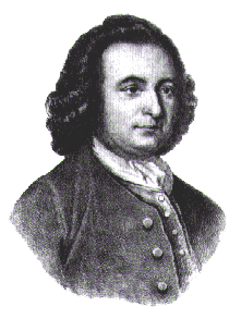 Mason County is named for George Mason (1725-1792) of Gunston Hall, planter, member of the Virginia House of Burgesses, author of the Virginia Declaration of Rights, and influential participant at the Constitutional Convention at Philadelphia. Ironically, the signature of George Mason does not appear on the United States Constitution. He left the proceedings in protest over the absence of a declaration of rights. His demonstration was largely responsible for the establishment of the most important feature of our United States Constitution, its Bill of Rights. Visit Gunston Hall Plantation's website to see names in the Mason Family genealogy. Mason County is named for George Mason (1725-1792) of Gunston Hall, planter, member of the Virginia House of Burgesses, author of the Virginia Declaration of Rights, and influential participant at the Constitutional Convention at Philadelphia. Ironically, the signature of George Mason does not appear on the United States Constitution. He left the proceedings in protest over the absence of a declaration of rights. His demonstration was largely responsible for the establishment of the most important feature of our United States Constitution, its Bill of Rights. Visit Gunston Hall Plantation's website to see names in the Mason Family genealogy.
Mason County was officially formed in 1789 from portions of Bourbon County. Its importance to the founding of Kentucky lies in its proximity to the Ohio River. Early long hunters and river spies began traversing the wilderness in the mid-1700s. Later, familiar names like Christopher Gist and Daniel Boone would bring the first white settlers down the Ohio and up through the Cumberland Gap to establish fortresslike settlements called 'stations.' In the mid 1700s, a young pioneer named Simon Kenton journeyed down the Ohio River in search of the legendary bountiful canelands. In 1775, he and a companion landed their craft at what was to become Limestone (now Maysville) and headed inland. 
In 1785, Arthur Fox and William Wood acquired 400 acres of land from Simon Kenton and established the town of Washington in honor of the Revolutionary War hero who would later become the first President of the United States. The early settlers to the area came from Virginia, Pennsylvania, New Jersey, North Carolina, and Maryland. Mason County was partitioned from Bourbon County, and is eighth in order of formation. At its formation, Mason County included one-fourth of the territory of KY in that part of the state east of the Licking River. Nineteen counties were later carved from the huge swath of geography that ran from what is now Campbell County at the northernmost point of the state, all the way to Pike County on the Virginia border. Today, the boundaries of Mason County are the Ohio River on the north, Lewis and Fleming Counties and on the east and by Robertson and Bracken Counties on the west. A century of partitioning left modern-day Mason County with an area of 241 square miles. The population at the 2000 U.S. Census was 16,800. Mason County is located in the Outer Bluegrass region of the state. The elevation in the county ranges from 485 to 1000 feet above sea level. Maysville, at the mouth of Limestone Creek,was known as Limestone prior to 1790. It was made a town in 1787 and in 1833 became a city. Washington, the old county seat, was once a thriving town in the uplands, but suffered a decline beginning in 1844, when the county seat was removed to Maysville. The image selected as a logo for the Mason County KyGenWeb is a rendering of a scenic view of Maysville. The image reflects the past, present and future of Mason County. Today's Maysville, with its familiar skyline of steeples, looks out upon the historic Ohio River that served as a highway for Native Americans and settlers alike. The futuristic lines of the distant Harsha Cable Stayed Bridge over the Ohio River speak to the future of mobility and commerce. Much more on Mason County is available at the Southeastern Genealogy Online website. This website maintained by: Marla McCullough Please report broken links to Marla. Passed W3C link-check on December 30, 2024. KYGenWeb State Coordinator Jeff Kemp Please contact the State Coordinator if you'd like to adopt a Kentucky county. This site is not responsible for URL changes by managers of external websites. Last Updated Wednesday, 26-Feb-2020 16:41:00 CST |
|