Indenture of Brice Thomas Fields, 1819 - 1901
Submitted by: Michael Redden
This document spelled exactly as written. When a letter was in doubt a (?) was used. Capitols and punctuation noted as used.
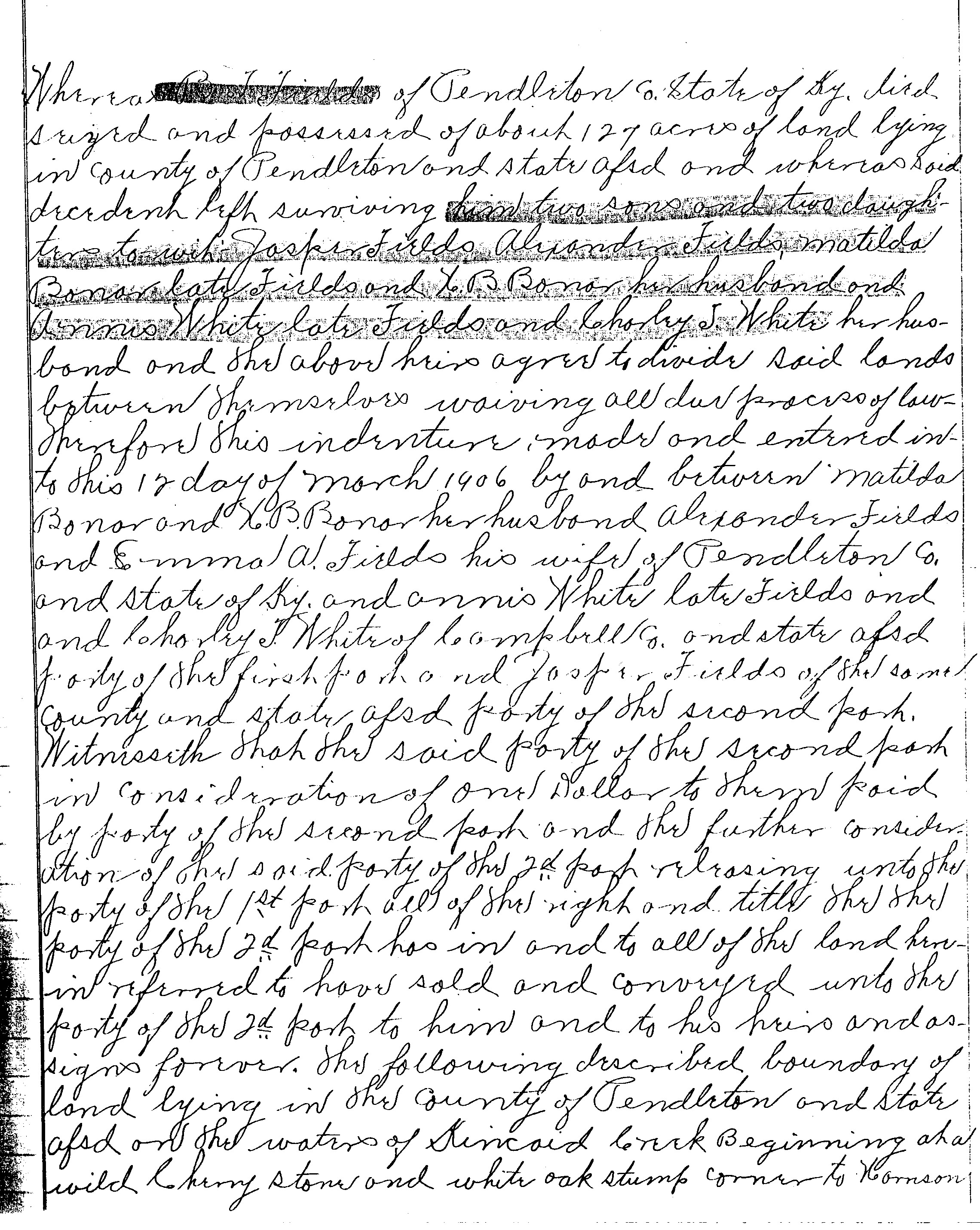
Whereas B. T. Fields of Pendleton Co. State of Ky. died seized and possessed of
about 127 acres of land lying in county of Pendleton and state afsd and whereas
said decedent left surviving him two sons and two daughters to wit Jasper Fields,
Alexander Fields, Matilda Bonar later Fields and H. B. Bonar her husband and
Annis White later Fields and Charley J. White her husband and the above heirs
agree to divide said lands between themselves waiving all due process of law.
Therefore this indenture, made and entered into this 12 day of March 1906 by and
between Matilda Bonar and H. B. Bonar her husband, Alexander Fields and Emma A.
Fields his wife of Pendleton Co. and state of Ky. and Annis White later Fields
and Charley J. White of Campbell Co. and state afsd party of the first
part and Jasper Fields of the same county and state afsd party of the second
part. Witnesseth that the said party of the second part in consideration of one
dollar to them paid by party of the second part and the further consideration of
the said party of the 2nd part releasing unto the party of the 1st part all of
the right and title there. The party of the 2nd part has in and to all of the
land herein referred to have sold and conveyed unto the party of the 2nd part
to him and to his heirs and assigns forever.
The following described boundary of land lying in the County of Pendleton and
the state afsd on the waters of Kincaid Creek Beginning at a wild cherry stone
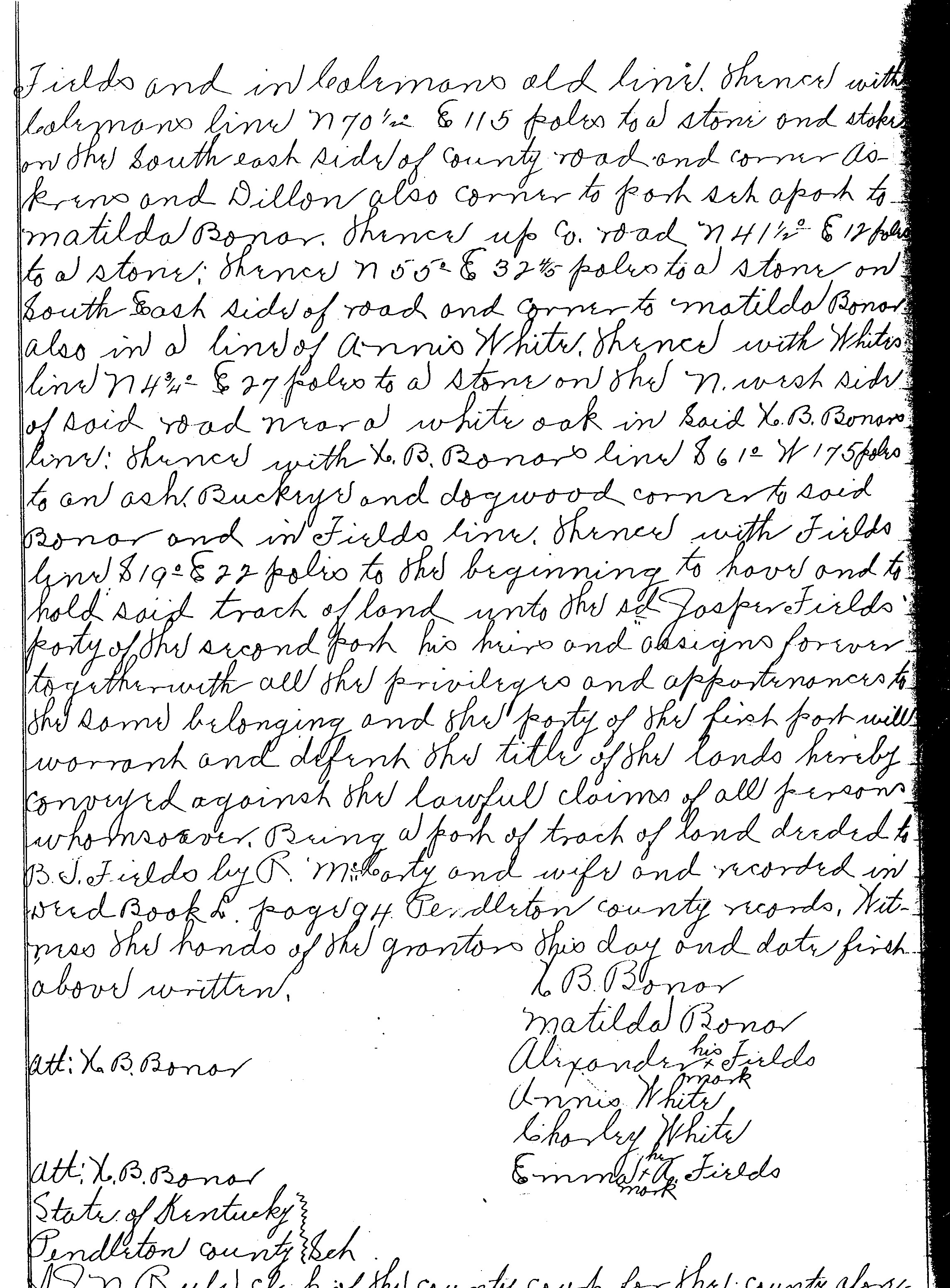
and white oak stump corner to Harrison Fields and in Colemans old line. Thence
with Colemans line N70 ½ º & 115 poles to a stone and stake on the Southeast
side of county road and corner Askerns and Dillon also corner to part set apart
to Matilda Bonar. Thence up co. road N41 ½º & 12 poles to a stone; thence N55º
& 32 4/5 poles to a stone on South East side of road and corner to Matilda Bonar
also in a line of Annis White.
Thence with Whites line N4 3/4º & 27 poles to a stone on the N. west side of
said road near a white oak in Said H. B. Bonars line; thence with H. B. Bonars
line & 61º W 175 poles to an ash, Buckeye and dogwood corner to said Bonar and
in Fields line. Thence with Fields line & 19º & 22 poles to the beginning to
have and to hold said track of land unto the sd Jasper Fields party of the
second part his heirs and assigns forever together with all the priviledges and
apportenances to the same belonging and the party of the first part will warrant
and defend the title of the lands hereby conveyed against the lawful claims of
all persons whomsoever. Being a part of track of land deeded to B. T. Fields by
R. McCarty and wife and recorded in Deed Book L page 94 Pendleton county
records. Witness the hands of the grantors this day and date first above
written.
Att: H. B. Bonar H. B. Bonar
Matilda Bonar
Alexander (X his mark) Fields
Annis White
Charley White
Emma (X her mark) Fields
Att: H. B. Bonar
State of Kentucky
Pendleton county Sch {schedule ?}
Scanned Original Documents below. To view a larger version, click on the document.
*My Note : afsd = aforesaid
sd = said
Additional information from the KY Land Office:
Surveying Measurements:
1 pole or 1 rod = 16.5 feet or 25 links
1 link = .66 feet or 7.92 inches
1 chain = 100 links, 4 rods or 66 feet
80 chains = 1 mile, 320 rods, 1760 yards or 5280 feet
1 acre = 1 sq. chains, 160 sq. rods, 4840 sq. yards, or 43,560 square feet
1 square mile = 1 section of land or 640 acres
Township - 36 sq. miles (36 mile sq. sections)
Problems or bad links should be reported to the webmaster.
NOTE: These records have been transcribed from several different sources, either by us or by other researchers and provided as a starting point to assist you in your research; we've verified as many as we could, but be aware that there may be errors (either mis-spellings on the original records, almost illegible writing on the records, and/or typing errors on my part), so make sure to double check them prior to assuming they're "the gospel truth". We will never deliberately include erroneous information in any part of this site.
These records have not been copied by either of this site's coordinators from other sites, as has been implied by some. Sources have included records from the E.E. Barton research files, military records, newspapers, microfilm and/or compiled lists that were provided by family members and other researchers. If you have records that you'd like to see added to this site, please contact either Sherri or Suzanne and we'll be glad to add them to this collection.©Copyright 2005-2018 by Pendleton County Genealogy Project All files on this website are copyrighted by their submitter and creator. They may be linked to, but may not be reproduced on another website or in any other form, without specific permission of the submitter, owner, publisher and this site moderator. Although public records are as such not copyrightable, the manner in which they are presented, including the notes, comments, etc. are. The information on this site is provided free of charge, by volunteers, for your personal use only.