 Breathitt County Kentucky
A KyGenWeb Project
|
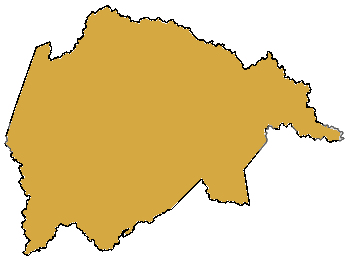
Breathitt County, the eighty-ninth county in order of formation, is located in eastern Kentucky in the mountainous Cumberland Plateau. The county is bordered by Lee, Wolfe, Magoffin, Knott, Perry, Leslie, Clay, and Owsley counties, and has an area of 494 square miles. It was formed in 1839 from Clay, Perry, and Estill counties, and named for Gov. John Breathitt (1832-34). Jackson is the county seat. The rugged foothill county is located on the edge of the Eastern Coal Field, where resources include coal, iron, and timber. Major rivers are the North and Middle forks of the Kentucky River and numerous tributaries, which include Quicksand, Troublesome, Lost, and Frozen Creeks. Stone artifacts found in the county indicate that prehistoric people lived there, often finding shelter under rock ledges and farming the Kentucky River bottoms. The first penetration of white settlers into the area began in the 1780s and included such family names as Haddix, Neace, Noble, Strong, Turner, and Watts. Most of them settled in the vicinity of Lost Creek. By the 1790s, the North Fork of the Kentucky River and sections near Quicksand and Frozen creeks were settled. The isolated mountain county grew slowly. For most of the nineteenth century it was sparsely inhabited by subsistence farmers; the only industries were logging and salt making. In the 1860s the Civil War ignited a long-running tradition of violence in Breathitt County. No major battles were fought there, but bitter animosity between Northern and Southern sympathizers led to sixty-four deaths, mostly of Confederate and Union soldiers who had been discharged or were home on leave. Capt. Bill Strong led a pro-Union faction of guerrillas in cattle rustling. A dispute over the division of spoils led to the Strong-Amis feud, which lasted into the 1870s. Feuding between the Little and Strong clans caused Gov. Preston H. Leslie (1871-75) to send sixty members of the state militia to Jackson on September 16, 1874. By the time the soldiers were withdrawn in December of 1874, their numbers had increased to five companies. A narrow margin in a local election in November 1878 rekindled hostilities and caused Gov. James B. McCreary (1875-79, 1911-15) to order troops to the county from mid-December 1878 to February 1879. In the early twentieth century, the Hargis-Marcum feud gave the county the tag "Bloody Breathitt." The Kentucky Union Railroad (later the Louisville & Nashville) entered the county between 1888 and 1890, and on July 15, 1891, Jackson became the southern terminus of the road. The Ohio & Kentucky (abandoned in 1935) was extended from Jackson up the valley of Frozen Creek. The railroads opened up the county's timber and coal resources, and the population rose from 8,705 in 1890 to 14,320 in 1900 and 17,540 in 1910. By the 1920s, most of the timber had been cleared, and the last of the large companies, Mowbray and Robinson, left the county in 1925. Fifteen thousand acres of the Robinson property at Quicksand were donated to the University of Kentucky as the Robinson Agricultural Experiment Substation and Robinson Forest. In 1929 completion of KY 15 gave the county access to Winchester on the west and Virginia on the east. Other county roads were built during the Great Depression by the Public Works Administration. Breathitt County once had a strong agricultural economy. By the 1930s, however, much of the land had been damaged by erosion or soil depletion. In 1987 farms occupied only 14 percent of the county land area, and a mere 22 percent of the farmland was under cultivation. Crops included hay, corn, and tobacco. The largest employers in 1990 were coal and mining-related industries. The population of Breathitt County was 14,221 in 1970; 17,004 in 1980; and 15,703 in 1990. From The Kentucky Encyclopedia, edited by John Kleber. Copyright 1992 |
About this site In the spring of 1996, a group of genealogists organized the Kentucky Comprehensive Genealogy Database Project, which evolved into the KyGenWeb Project. The idea was to provide a single entry point for genealogy data and research for all counties in Kentucky. In addition, the information for each county would be indexed and cross-linked to make it easier for researchers to find a name or data that they sought. In June 1996, as the KyGenWeb Project was nearing 100% county coverage, interested volunteers decided to create a similar set of pages for all states, establishing The USGenWeb Project. Volunteers were found who were willing to coordinate the efforts for each state, and additional volunteers were and are being sought to create and maintain websites for every county in the United States. This site is an ONGOING EFFORT and we need YOUR help. What kind of help do we need? In a word: Information. Information you can add or correct contributes to the benefit of all Breathitt County family researchers. If you have something you'd like to contribute to this site please contact the site coordinator. Please do not include information on those still living or that violates copyright law. If you have doubts or questions, please contact the site coordinator.
Special thanks to previous Breathitt County coordinators for their efforts in this project:  Golden Combs Ferguson KYGenWeb Contacts Jeff KempState Coordinator Tricia AanderudAssistant State Coordinator |