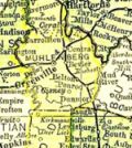
Muhlenberg County Kentucky
Cemetery Records
Lee Hill Church Cemetery
| Surname | Name | Birth | Death | Other Information | Images |
|---|---|---|---|---|---|
| Bratcher | Misty | 1975 | 1975 | ||
| Bratcher | Valorie Renae | 1974 | 1974 | ||
| Gray | C.B. | 1907 | 1970 | Funeral marker | |
| Gray | Viola D. | 1911 | 1976 | Funeral marker | |
| Groves | Riley Jackson | 15 July 1892 | 2 July 1979 | Information from obituary | |
| Rolley | Wendell Dale | 18 Dec 1974 | 19 Dec 1974 | ||
| Ward | William | 18 July 1923 | 7 July 1979 | Information from obituary |
Note: This cemetery was founded in the 1970s and is still in use. According to the website Findagrave, there are currently approximately 50 burials in this cemetery.
Directions: From Greenville, take US Route 62 West about 3 miles to Bards Hill Rd. Turn south onto Bards Hill. Go about .4 miles to Sharon Depoy Rd. Turn onto Sharon Depoy Rd. Lee Hill Church Cemetery is about .2 mile on the right.
Coordinates: 37.208733, -87.242715
Citation: Hammers, Marian G. “Lee Hill Church Cemetery.” Muhlenberg County Kentucky Cemeteries. Vol. 4. Madisonville, KY: Marian G. Hammers, 1980. Page 110.
Updated October 4, 2017